Friday☕️


Economics & Markets:
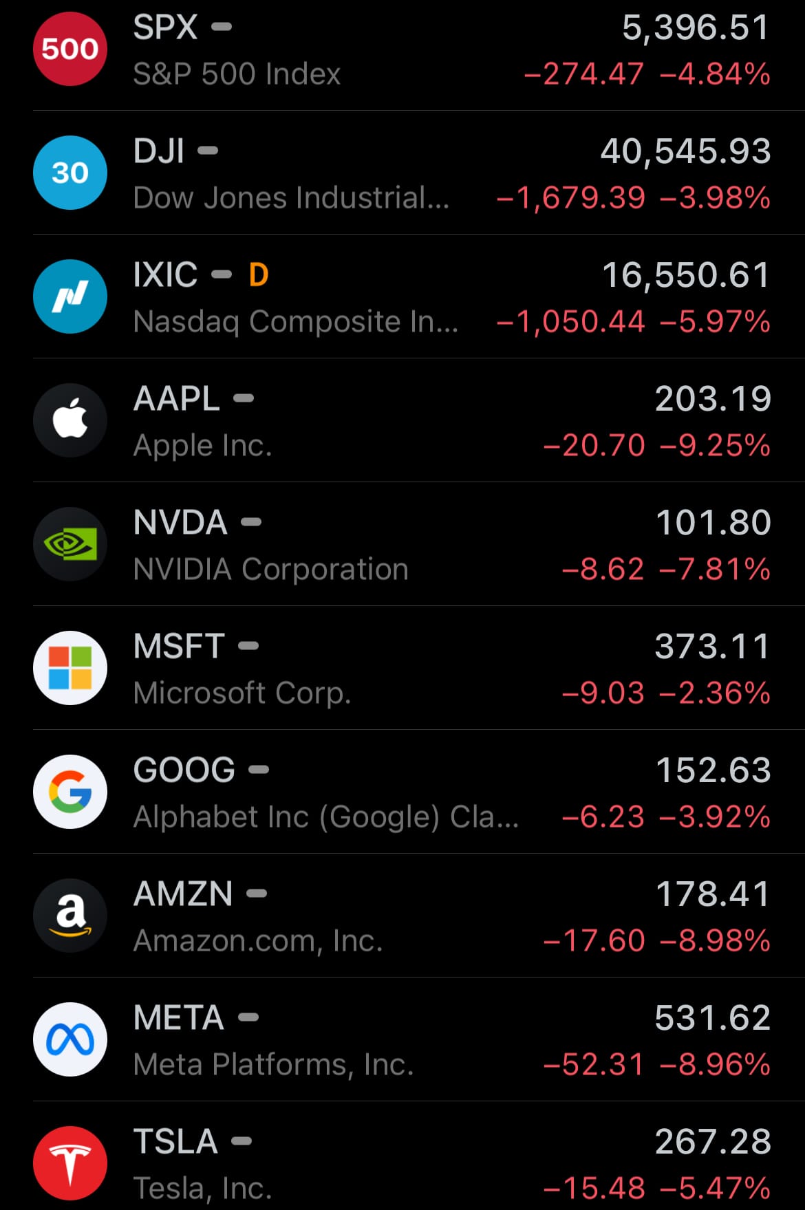
- Yesterday, April 3, 2025, the U.S. stock market experienced a decline after President Donald Trump announced new reciprocal tariffs on imported goods. The S&P 500 fell 4.8%, erasing $2.4 trillion in market value—its steepest single-day drop since June 2020—while the Dow Jones Industrial Average decreased by 1,679 points, or nearly 4%, and the Nasdaq Composite fell 6%.
- These tariffs, set at 10% on imports from all countries, with higher rates like 34% on China and 25% on vehicles from specific nations, were designed to mirror trade measures already imposed on the U.S., with rates calculated at 50% of the tariffs other countries apply to American goods. The administration positioned the move as a way to level the playing field in international trade.
- Yesterday’s U.S. stock market:
- Yesterday’s commodity market:

- Yesterday’s crypto market:

Environment & Weather:
- Yesterday, April 3, 2025, Mount Merapi, one of Indonesia’s most active volcanoes, erupted, with ash and volcanic material reaching heights of 1,500 to 5,000 meters above its peak. Situated in Central Java near Yogyakarta, this eruption saw plumes of ash and gas extending from Merapi’s summit, which stands at 2,911 meters (9,551 feet) above sea level. This vertical reach aligns with Merapi’s history of powerful eruptions, prompting concerns for nearby communities and aviation safety. Local authorities have issued warnings, urging residents within a 3-7 kilometer radius to prepare for possible pyroclastic flows and lahars, hazards frequently associated with Merapi’s activity.
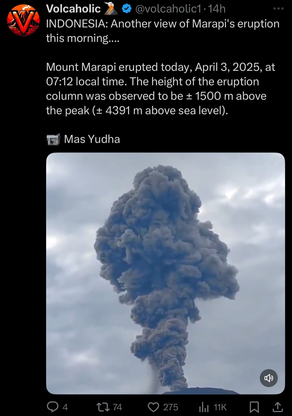
- Mount Merapi, known as the "Mountain of Fire," is a stratovolcano formed by the subduction of the Indo-Australian Plate beneath the Eurasian Plate, driving its frequent eruptive behavior. Its recorded history dates back to 1548, with major eruptions occurring every 5-10 years, including the 1006 event that covered central Java in ash and the 2010 eruption that claimed 353 lives and displaced over 350,000 people with pyroclastic flows extending up to 15 kilometers. The volcano’s steep lava dome often collapses during eruptions, unleashing deadly avalanches of hot gas and rock. As a designated Decade Volcano, Merapi’s proximity to millions—over 11,000 reside on its slopes—ensures it remains a focal point for Indonesia’s volcanological monitoring efforts due to its persistent threat.
Space:
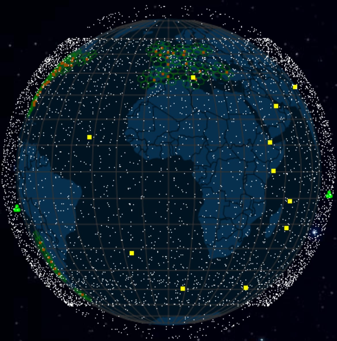
- Yesterday, April 3, 2025, SpaceX conducted a Falcon 9 launch from Vandenberg Space Force Base in California, placing 27 Starlink satellites into low Earth orbit (LEO). The rocket’s first stage separated and landed on a droneship in the Pacific Ocean, a routine maneuver for SpaceX’s reusable launch system. The mission was part of the company’s ongoing effort to expand the Starlink satellite network, intended to provide internet services worldwide.
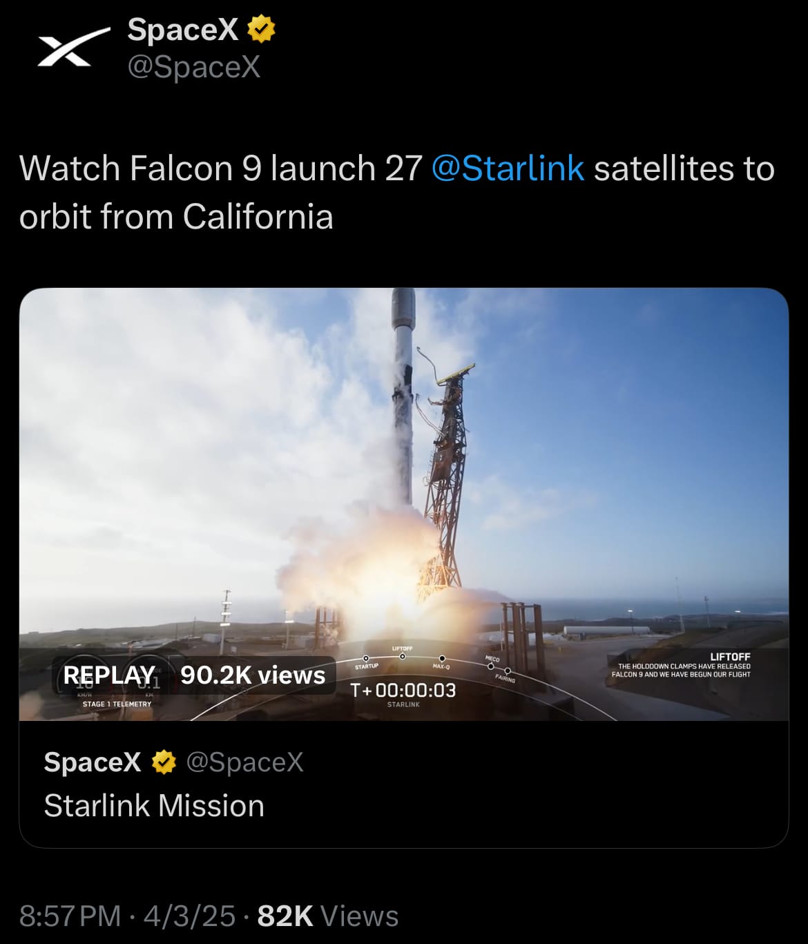
- The payload consisted of 27 Starlink V2 Mini satellites, designed with updated technology including phased array antennas and optical links for intersatellite communication. These additions bring the number of Starlink satellites in orbit to over 7,500, part of a larger plan that will see the constellation grow to tens of thousands of units. Positioned at roughly 550 kilometers above Earth, the satellites aim to support internet access across various regions. The project continues to evolve as SpaceX works toward its stated objectives, while managing the challenges of operating a large-scale satellite network in LEO.
- Live Starlink orbital map below (click to view):
Science & Technology:
- Yesterday, April 3, 2025, Anduril unveiled its Seabed Sentry capabilities, introducing a new system for underwater monitoring. Seabed Sentry is presented as a network of AI-supported, cable-less sensor nodes designed for extended underwater surveillance, utilizing Anduril’s Lattice AI software and Ultra Maritime’s Sea Spear sonar technology. The system features a depth rating of over 500 meters, a payload capacity exceeding 0.5 cubic meters, and endurance ranging from months to years, with deployment facilitated by autonomous underwater vehicles (AUVs). It aims to provide persistent monitoring and real-time communication, targeting applications such as tracking underwater objects and supporting maritime operations.
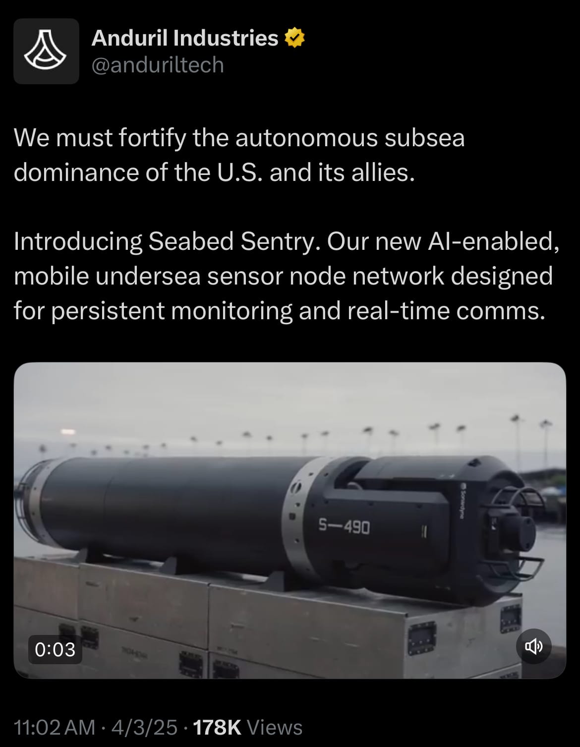
- The Seabed Sentry system expands on existing underwater monitoring methods, which include smaller sensors and submarine-based systems already in use globally. It is designed to offer a scalable and flexible network for observing a range of underwater activities, such as submarines, drones, and other movements, across larger areas. While current technologies provide some level of detection, this system is intended to enhance coverage and connectivity, processing data directly at the sensor level for quicker insights. Its modular setup allows it to adapt to various tasks, potentially including port monitoring or infrastructure observation, though its effectiveness and practical impact remain to be fully assessed as it enters operational use.
Statistic:
- Largest assets by market capitalization:
- 🇺🇸 Gold: $21.063T
- 🇺🇸 Apple: $3.052T
- 🇺🇸 Microsoft: $2.773T
- 🇺🇸 NVIDIA: $2.483T
- 🇺🇸 Amazon: $1.890T
- 🇺🇸 Alphabet (Google): $1.848T
- 🇺🇸 Silver: $1.800T
- 🇸🇦 Saudi Aramco: $1.695T
- 🇺🇸 Bitcoin: $1.651T
- 🇺🇸 Meta Platforms: $1.346T
- 🇺🇸 Berkshire Hathaway: $1.143T
- 🇺🇸 Tesla: $859.71B
- 🇹🇼 TSMC: $816.25B
- 🇺🇸 Broadcom: $724.14B
- 🇺🇸 Eli Lilly: $708.59B
- 🇺🇸 Walmart: $699.55B
- 🇺🇸 Visa: $654.68B
- 🇺🇸 JPMorgan Chase: $639.44B
- 🇨🇳 Tencent: $592.39B
- 🇺🇸 UnitedHealth: $494.34B
- 🇺🇸 SPDR S&P 500 ETF Trust: $492.57B
- 🇺🇸 Exxon Mobil: $487.84B
- 🇺🇸 Mastercard: $483.70B
- 🇺🇸 Costco: $429.07B
- 🇺🇸 Procter & Gamble: $404.22B
History:
- The history of underwater surveillance, intelligence, and reconnaissance began in earnest during the early 20th century, though rudimentary concepts emerged earlier with the advent of naval warfare. In the late 19th and early 20th centuries, navies relied on basic tools like periscopes and hydrophones—simple listening devices lowered into the water—to detect enemy vessels. World War I marked a turning point, as hydrophones were systematically deployed to counter the growing threat of submarines, particularly German U-boats. By World War II, sonar (Sound Navigation and Ranging) had become a cornerstone technology, with active sonar emitting sound pulses to locate objects and passive sonar quietly listening for enemy noise. The Cold War accelerated innovation, as the U.S. and Soviet Union competed to monitor each other’s submarine fleets, leading to the development of the Sound Surveillance System (SOSUS)—a network of underwater microphones placed on the seafloor to track Soviet subs across vast ocean expanses. These early systems laid the groundwork for understanding the underwater domain, driven by military necessity and basic acoustic principles.
- Advancements in the late 20th and early 21st centuries transformed underwater surveillance into a sophisticated, multi-dimensional field. SOSUS evolved into the Integrated Undersea Surveillance System (IUSS), incorporating mobile and fixed sensors, while nuclear-powered submarines equipped with advanced sonar arrays became roving intelligence platforms. The introduction of unmanned underwater vehicles (UUVs) and drones in the 1990s and 2000s expanded capabilities further, allowing for autonomous, long-duration missions without risking human lives. Today, cutting-edge sensors—like those in Anduril’s Seabed Sentry announced on April 3, 2025—leverage AI, high-resolution sonar, and networked systems to monitor submarines, drones, and other underwater activities at scale. Modern systems integrate real-time data processing, satellite communication, and modular designs, far surpassing the static, labor-intensive methods of the past. This evolution reflects a shift from localized, manual detection to a global, automated underwater awareness grid, driven by technological leaps and the strategic importance of the subsea environment.

Thanks for reading!
Earth is complicated, we make it simple.
Click image to view the Earth Intelligence System:


Support/Suggestions Email:
earthintelligence@earthintel.news