Friday☕️


Iranian Internet Connection:
- As of June 20, 2025, Iran is experiencing a significant internet disruption, with national connectivity reported at 3% of normal levels. This outage affects both mobile and fixed-line internet services, limiting access for the majority of the population, though a small number of users have managed to connect using multi-hop VPNs, as noted in social media posts from individuals in Iran on June 19.
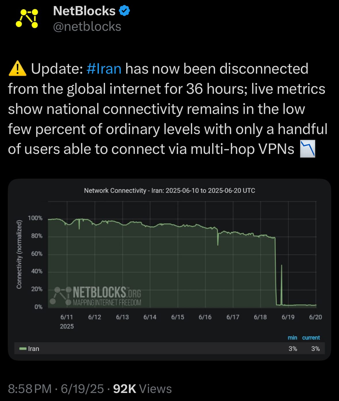
- The internet outage coincides with heightened tensions following military actions between Iran and Israel, including airstrikes reported on June 13, 2025, which may have prompted the government to restrict access, potentially to manage information flow during this period. This approach has been observed in previous instances of civil unrest in Iran, such as the 2019 fuel protests and the 2022 protests following Mahsa Amini’s death, where internet restrictions were implemented. The disruption affects various sectors, including businesses that rely on online operations—given Iran’s reported internet speed rankings of 69th for mobile and 142nd for broadband in April 2025—and limits public access to global news and communication platforms, which has drawn attention from international observers.
- As of early June 20, 2025, the internet remains largely unavailable, impacting daily activities, education, and services like banking and navigation. The international community, including organizations focused on internet freedom, is monitoring the situation, noting a significant reduction in internet traffic. The ongoing situation continues to be a point of global interest, with potential implications for communication and economic stability in Iran.
Economics & Markets:
- Today‘s commodity market:

- Today’s crypto market:

Environment & Weather:
- As of today, June 20, 2025, Mexico is recovering from Hurricane Erick, which made landfall as a Category 3 storm near Puerto Escondido, Oaxaca, on June 19. Previously reaching Category 4 strength with 125 mph winds, the storm has weakened to a tropical storm and is expected to become a low-pressure area by day’s end. Impacts include power outages affecting over 120,000 households, widespread flooding, landslides, and damage to infrastructure, including hospitals and highways.
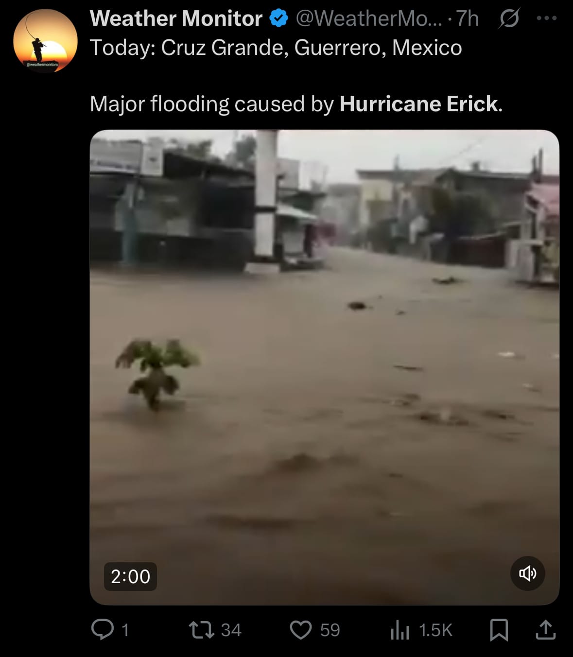
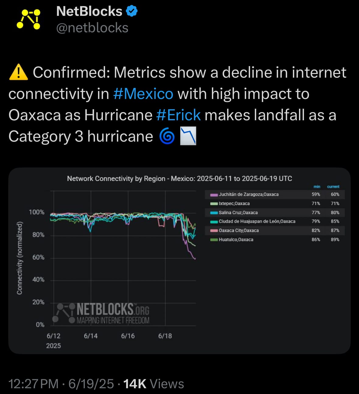
- Relief efforts are active, with thousands of first responders and organizations like Direct Relief and All Hands and Hearts supporting Oaxaca and Guerrero. Around 200 people are in shelters, one injury is reported, and 1 death has been confirmed. Power restoration has reached 25% in some areas, with ongoing efforts to address flooding risks.
Science & Technology:
- Midjourney’s V1 video generation model, launched on June 18, 2025, enables users to convert static images into videos up to 20 seconds long, accessible via its web platform and Discord with a subscription. It offers basic animation adjustments and builds on Midjourney’s established image generation strengths, catering to creative professionals. While it delivers high-quality visuals, V1 is limited to image-to-video functionality and lacks audio integration or text-based video creation, unlike some competitors.

- In contrast, OpenAI’s Sora, released in December 2024, supports text-to-video and image-to-video generation, producing 20-second clips at 1080p with advanced customization features like Remix and Storyboard, though it also lacks audio. Google’s Veo 3, launched around May 2025, generates 8-second videos with integrated audio, including dialogue and effects, and excels in realism, available through Google AI plans. Tools like Runway and Pika Labs provide additional options, with Runway focusing on quality and Pika on ease of use. Each tool serves distinct needs: Veo 3 for audio and realism, Sora for customization, and Midjourney V1 for image-based video creation.
Statistic:
- Top countries by population:
- 🇮🇳 India: 1,463,475,130
- 🇨🇳 China: 1,416,192,944
- 🇺🇸 U.S.A.: 347,220,070
- 🇮🇩 Indonesia: 285,653,843
- 🇵🇰 Pakistan: 255,099,885
- 🇳🇬 Nigeria: 237,380,557
- 🇧🇷 Brazil: 212,787,898
- 🇧🇩 Bangladesh: 175,622,650
- 🇷🇺 Russia: 144,022,065
- 🇪🇹 Ethiopia: 135,368,189
- 🇲🇽 Mexico: 131,914,123
- 🇯🇵 Japan: 123,122,959
- 🇪🇬 Egypt: 118,310,635
- 🇵🇭 Philippines: 116,758,489
- 🇨🇩 DR Congo: 112,723,887
- 🇻🇳 Vietnam: 101,580,112
- 🇮🇷 Iran: 92,392,013
- 🇹🇷 Turkey: 87,679,060
- 🇩🇪 Germany: 84,089,386
- 🇹🇭 Thailand: 71,621,307
History:
- The earliest known attempts to predict hurricanes, dating back to the 17th and 18th centuries, were rooted in anecdotal observations and rudimentary instruments across hurricane-prone regions. Sailors in the Caribbean, European colonists in the Americas, and coastal communities in Asia noted signs like erratic winds, plummeting barometric pressure, and menacing cloud formations, using handheld barometers and wind gauges to assess storm proximity. By the mid-19th century, formalized weather observation networks emerged, marking the foundation of modern meteorology. In 1855, France established its national meteorological service, coordinating storm data across its Caribbean colonies like Martinique. The British Royal Navy, through its Hydrographic Office (founded 1795), compiled ship logs to map cyclone patterns in the Atlantic and Indian Oceans. In 1870, the U.S. Weather Bureau began collecting telegraphic data, enabling storm tracking. Meanwhile, in Cuba, Jesuit priest Benito Viñes laid a critical foundation at the Belen Observatory in the 1870s, using barometric readings, wind patterns, and cloud observations to issue some of the earliest hurricane warnings. Japan’s Tokyo Meteorological Observatory, founded in 1875, tracked typhoons with similar methods, while India’s Meteorological Department, also established in 1875, monitored Bay of Bengal cyclones. Despite these efforts, sparse data and slow communication meant forecasts were often inaccurate, with storm paths misjudged by hundreds of miles, leaving communities vulnerable. As of June 20, 2025, these early foundations remain a testament to global efforts to understand tropical cyclones.
- The 20th century brought transformative advancements, with countries building on these foundations through technology and international cooperation. In the 1940s, the U.S. introduced radiosondes for upper-atmosphere data and launched the first “Hurricane Hunter” flight in 1943, a milestone in direct storm observation. Australia, prone to Southern Hemisphere cyclones, established its Bureau of Meteorology in 1908 and adopted radar by the 1950s, strengthening regional forecasting. The launch of TIROS-1 in 1960 by the U.S. provided the first global storm imagery, followed by Japan’s GMS-1 satellite in 1977, which revolutionized typhoon tracking in the Pacific. France and the UK contributed through European weather networks, with the UK Met Office (founded 1854) integrating satellite data by the 1970s. India advanced with INSAT satellites in the 1980s, while Doppler radar, adopted globally in the 1980s, enabled precise precipitation and wind tracking. By the 1990s, supercomputers powered numerical models like the U.S.’s GFDL and HWRF, Australia’s ACCESS-TC, and Europe’s ECMWF, integrating data from satellites, buoys, and GPS dropsondes. The World Meteorological Organization, founded in 1950, fostered global data sharing, amplifying these efforts. Today, as of June 2025, AI-driven models—such as NOAA’s in the U.S., China’s Pangu-Weather, and Japan’s RIKEN-based systems—achieve 48-hour track forecast errors under 80 miles. Uncrewed drones, used by nations like the Philippines and Fiji, and advanced radar systems further refine predictions of storm surge and intensity, building on centuries of foundations to save lives.
Image of the day:

Thanks for reading!
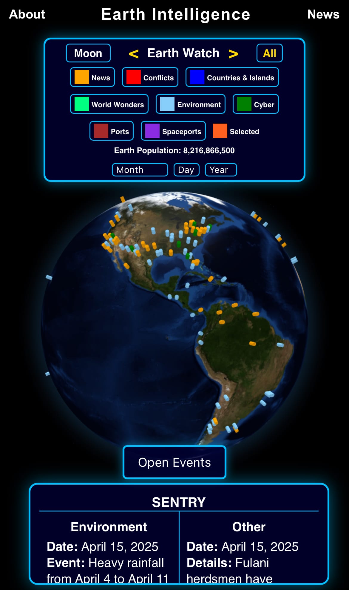
Earth is complicated, we make it simple.
Click image to view the Earth Intelligence System:


Support/Suggestions Email:
earthintelligence@earthintel.news