Monday☕️


Trending:
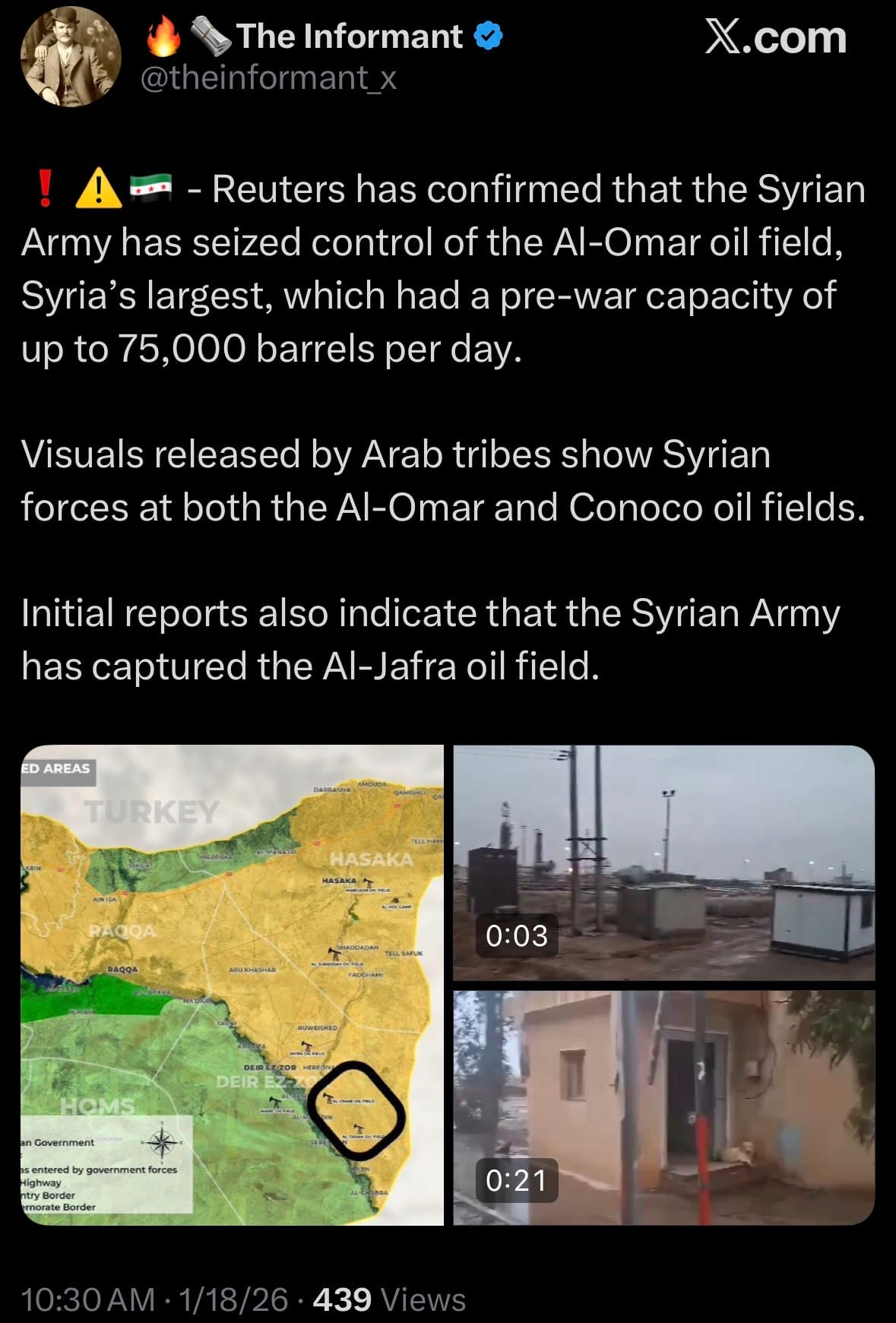
- On January 18, 2026, Syrian government forces took control of the Al-Omar oil field (Syria’s largest, pre-war capacity up to 75,000 barrels per day) and the Conoco gas field in eastern Deir ez-Zor province after the U.S.-backed Syrian Democratic Forces (SDF) withdrew. Syrian officials, Reuters, and the Syrian Observatory for Human Rights confirmed the takeover; visuals from allied Arab tribes showed government troops at both sites. Initial reports also suggest the Al-Jafra oil field was captured, though this is less verified. These gains followed rapid advances over the previous 24-48 hours, including the seizure of Tabqa city and its dam, plus towns such as al-Shuhail, Busayra, Baghouz, Hatla, Gharanij, Muhaymidah, al-Hawaij, Dhiban, Abu Hamam, Susah, Shafa, and others along the eastern Euphrates. With Arab tribal support, Damascus now controls most of Deir ez-Zor province—vital for oil, gas, and wheat—representing a major economic and territorial setback for the SDF amid ongoing talks and clashes. No significant casualties were reported from the oil field takeovers.
- The Syrian government has officially announced the capture of Raqqa city after launching what it called the fourth battle for the city. Arab tribal fighters allied with the Syrian Army entered Raqqa, dismantled SDF positions, and reached the city center, with reports confirming the SDF withdrew and ceded control. Syrian forces and tribesmen are now conducting clearing operations citywide, with concerns raised about the security of local prisons. Visuals from the center showed Kurdish statues being removed, while residents reacted to the swift change in control. Raqqa, formerly a major ISIS stronghold infamous for atrocities and later liberated by Kurdish-led forces, has changed hands again in the rapidly evolving post-Assad conflict.
Economics & Markets:
- Yesterday’s commodity market:

- Yesterday’s crypto market:

Geopolitics & Military Activity:
- On January 17, 2026, U.S. Central Command (CENTCOM) announced that its forces conducted a precision strike in northwest Syria on January 16, killing Bilal Hasan al-Jasim, an Al-Qaeda-affiliated terrorist leader with direct ties to the ISIS operative responsible for the December 13, 2025, ambush in Palmyra, Syria. That attack killed two U.S. Army soldiers (Sgt. Edgar Brian Torres-Tovar and Sgt. William Nathaniel Howard) and one American civilian interpreter, while wounding three others.

- CENTCOM described al-Jasim as an experienced planner of attacks and confirmed his connection to the Palmyra gunman. Adm. The action builds on Operation Hawkeye Strike, initiated December 19, 2025, which involved U.S. and partner forces striking over 100 ISIS sites with more than 200 precision munitions. Over the past year, coalition operations in Syria have detained more than 300 suspected ISIS operatives and killed over 20, aiming to degrade the group’s capabilities and prevent resurgence.
Space:
- On January 18, 2026, SpaceX successfully launched the Starlink Group 6-100 mission using a Falcon 9 rocket from Space Launch Complex 40 at Cape Canaveral Space Force Station in Florida. The rocket lifted off at 6:31 PM EST, deploying 29 Starlink V2 Mini satellites into low Earth orbit to expand the company's global broadband constellation. The first-stage booster landed successfully on a droneship in the Atlantic, marking another reuse milestone.

- This mission is the latest in SpaceX's rapid Starlink deployment cadence for 2026, adding to the thousands of satellites already providing internet service worldwide. No anomalies were reported, and the satellites are expected to begin operational checks shortly after deployment. The launch highlights SpaceX's ongoing efforts to densify the constellation for improved coverage and performance.
Statistic:
- Largest assets on Earth by market capitalization:
- Gold – $31.991 T
- Silver – $5.063 T
- 🇺🇸 NVIDIA – $4.534 T
- 🇺🇸 Alphabet (Google) – $3.987 T
- 🇺🇸 Apple – $3.775 T
- 🇺🇸 Microsoft – $3.418 T
- 🇺🇸 Amazon – $2.556 T
- Bitcoin – $1.906 T
- 🇹🇼 TSMC – $1.775 T
- 🇺🇸 Broadcom – $1.667 T
- 🇸🇦 Saudi Aramco – $1.599 T
- 🇺🇸 Meta Platforms – $1.563 T
- 🇺🇸 Tesla – $1.455 T
- 🇺🇸 Berkshire Hathaway – $1.064 T
- 🇺🇸 Walmart – $954.35 B
- 🇺🇸 Eli Lilly – $930.88 B
- 🇺🇸 JPMorgan Chase – $850.62 B
- 🇺🇸 Vanguard S&P 500 ETF (VOO) – $833.73 B
- 🇺🇸 iShares Core S&P 500 ETF (IVV) – $772.42 B
- 🇺🇸 SPDR S&P 500 ETF (SPY) – $712.18 B
- 🇨🇳 Tencent – $709.57 B
- 🇰🇷 Samsung – $675.81 B
- 🇺🇸 Visa – $633.58 B
- Platinum – $585.72 B
- 🇺🇸 Vanguard Total Stock Market ETF (VTI) – $576.69 B
- 🇺🇸 Exxon Mobil – $553.75 B
- 🇺🇸 Oracle – $549.02 B
History:
- Aircraft surveillance and airborne intelligence evolved from simple observation into one of the most complex sensing systems ever built, driven by the need to detect, identify, and respond to threats moving at speed through airspace. Early air intelligence relied on human eyes—balloons and pilots during World War I (1914–1918) sketching enemy positions and spotting artillery—but this quickly proved insufficient as aircraft multiplied. The decisive breakthrough was radar. In the 1930s, nations developed radio detection, but Britain operationalized the first fully integrated air surveillance system with Chain Home (1938–1939), feeding early warning into centralized command-and-control. During the Battle of Britain (1940), radar, ground observers, and fighter direction fused into a coherent air defense and interception network. World War II expanded this architecture dramatically: ground-based early warning radar, airborne interception radar, gun-laying radar for anti-aircraft fire, maritime radar, and the first Identification Friend or Foe (IFF) systems to distinguish allies from adversaries. By war’s end, aircraft intelligence was no longer about spotting planes—it was about continuous tracking, classification, prediction, and response across entire regions.
- The Cold War scaled aircraft surveillance to the continental and global level. Faster jets, nuclear bombers, and later cruise missiles forced nations to build layered systems combining ground radar, airborne early warning aircraft, signals intelligence, and space-based sensors. Airborne radar platforms extended visibility beyond the horizon, while centralized command centers fused data into a single operational picture. Civil aviation evolved alongside military systems, creating standardized transponder technologies to ensure safety and coordination: Mode A (identity), Mode C (altitude), Mode S (unique aircraft addressing), and ultimately ADS-B, where aircraft continuously broadcast precise GPS-based position and velocity. Today’s global airspace is tracked through a hybrid of radar, ADS-B, multilateration, and satellite sensing. Military aircraft operate differently—often reducing, encrypting, masking, or disabling transponders during sensitive missions—shifting tracking into primary radar, infrared sensing, passive radio-frequency detection, and classified identification networks. Turning off a transponder hides an aircraft from the civilian picture, not from the battlespace itself, where multiple sensing layers still track movement and intent.
- In the modern era, aircraft intelligence and surveillance is a competition in sensor fusion, coverage, and response speed. The United States maintains a decisive edge through scale and integration: civil air tracking managed by the FAA feeds into defense surveillance operated by the U.S. Air Force and Navy, supported by space-based sensing from the National Reconnaissance Office, geospatial fusion by the National Geospatial-Intelligence Agency, and signals intelligence from the National Security Agency. NATO nations operate interoperable regional systems, while Russia emphasizes dense, defense-centric radar and integrated air defense, and China has rapidly expanded ground radar, airborne early warning, and space-based surveillance to control regional airspace. At the apex of U.S. and Canadian aerospace awareness sits NORAD—the North American Aerospace Defense Command—established in 1957–1958 to provide unified warning, tracking, and control of aerospace threats to North America. NORAD fuses radar, airborne surveillance, and space sensors into a continuous continental air picture, making it the most mature large-scale air surveillance command in the world. The U.S. reigns supreme in aircraft intelligence not because of a single system, but because it built a full-stack architecture—standards, sensors, intelligence agencies, and response forces—capable of seeing, understanding, and acting across the sky anywhere on Earth.
Image of the day:

Thanks for reading! Earth is complicated, we make it simple.
- Click below if you’d like to view our free EARTH WATCH globe:
- Download our mobile app:


Click below to view our previous newsletters:

Support/Suggestions Email:
earthintelligence@earthintel.news