Thursday☕️


Trending:
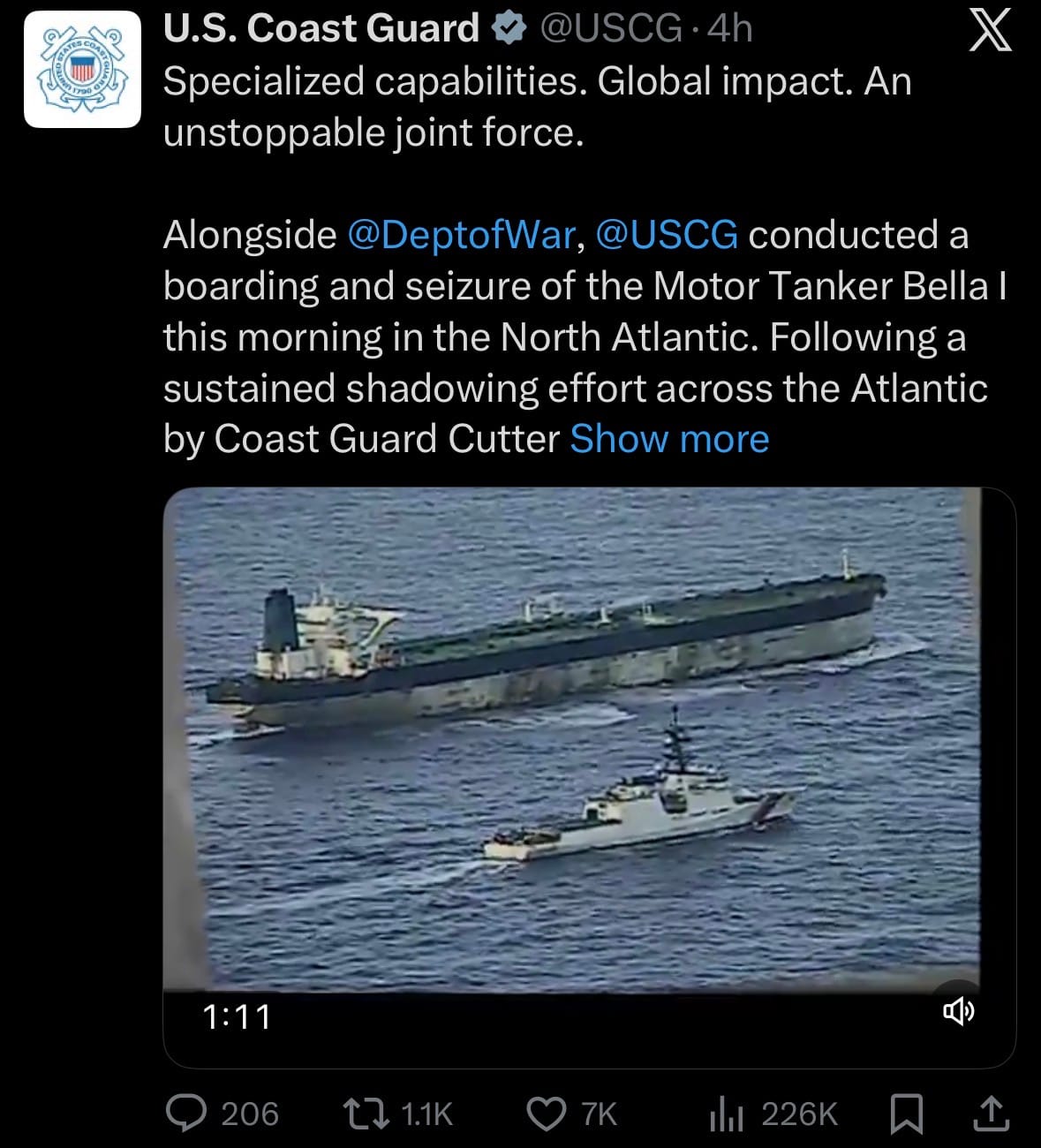
- On January 7, 2026, U.S. forces seized two sanctioned oil tankers linked to Venezuelan crude in separate operations: the Marinera (formerly Bella 1, Russian-flagged) in the North Atlantic near Iceland, and the M/T Sophia (described as stateless) in the Caribbean Sea. The Marinera, pursued for weeks after evading a prior boarding attempt near Venezuela, was intercepted despite Russian naval escort (including a submarine); the Sophia was boarded pre-dawn without incident. Both vessels were part of "dark fleet" networks accused of transporting sanctioned oil, with seizures executed under judicial warrants by the U.S. Coast Guard, supported by military assets.
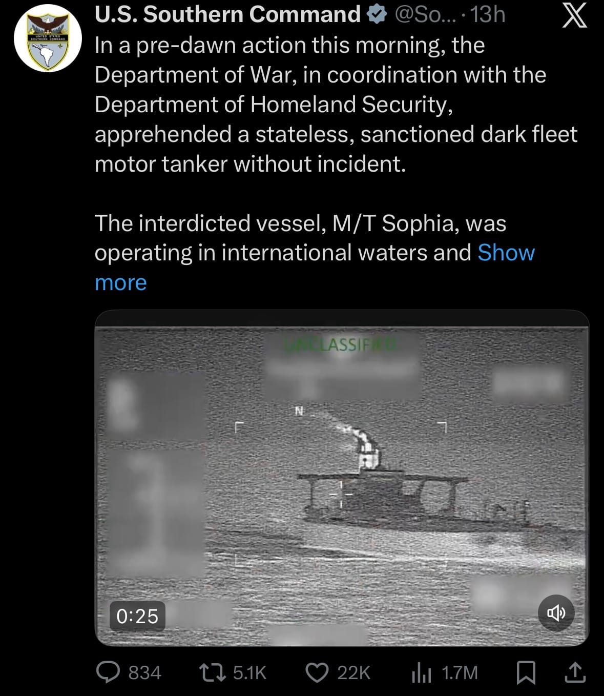
- The actions extend Operation Southern Spear and the U.S. blockade on Venezuelan oil flows post-Maduro's capture, with crews potentially facing prosecution and cargoes redirected. Russia condemned the Marinera seizure as "piracy," demanding crew safety, while the UK provided operational support. No casualties were reported, and the tankers are being escorted to U.S. ports. These seizures demonstrate continued U.S. enforcement against sanctions evasion globally, targeting shadow fleets to disrupt illicit trade. The involvement of a Russian-flagged vessel raises risks of diplomatic friction amid broader U.S.-Russia tensions.
Economics & Markets:
- Yesterday’s U.S. stock market:

- Yesterday’s commodity market:

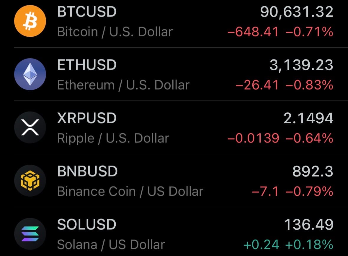
- Yesterday’s crypto market:
Environment & Weather:
- On January 7, 2026 (evening local time), heavy rainfall caused severe flash flooding in Hu’u village, Dompu Regency, West Nusa Tenggara Province, Indonesia. Floodwaters rapidly inundated residential areas, reaching depths of up to 1-2 meters in some homes, forcing dozens of families to evacuate to higher ground or temporary shelters. Local reports showed submerged roads, damaged houses, and disrupted access, with emergency teams assisting residents and clearing debris; no fatalities were immediately reported, though several people sustained minor injuries.
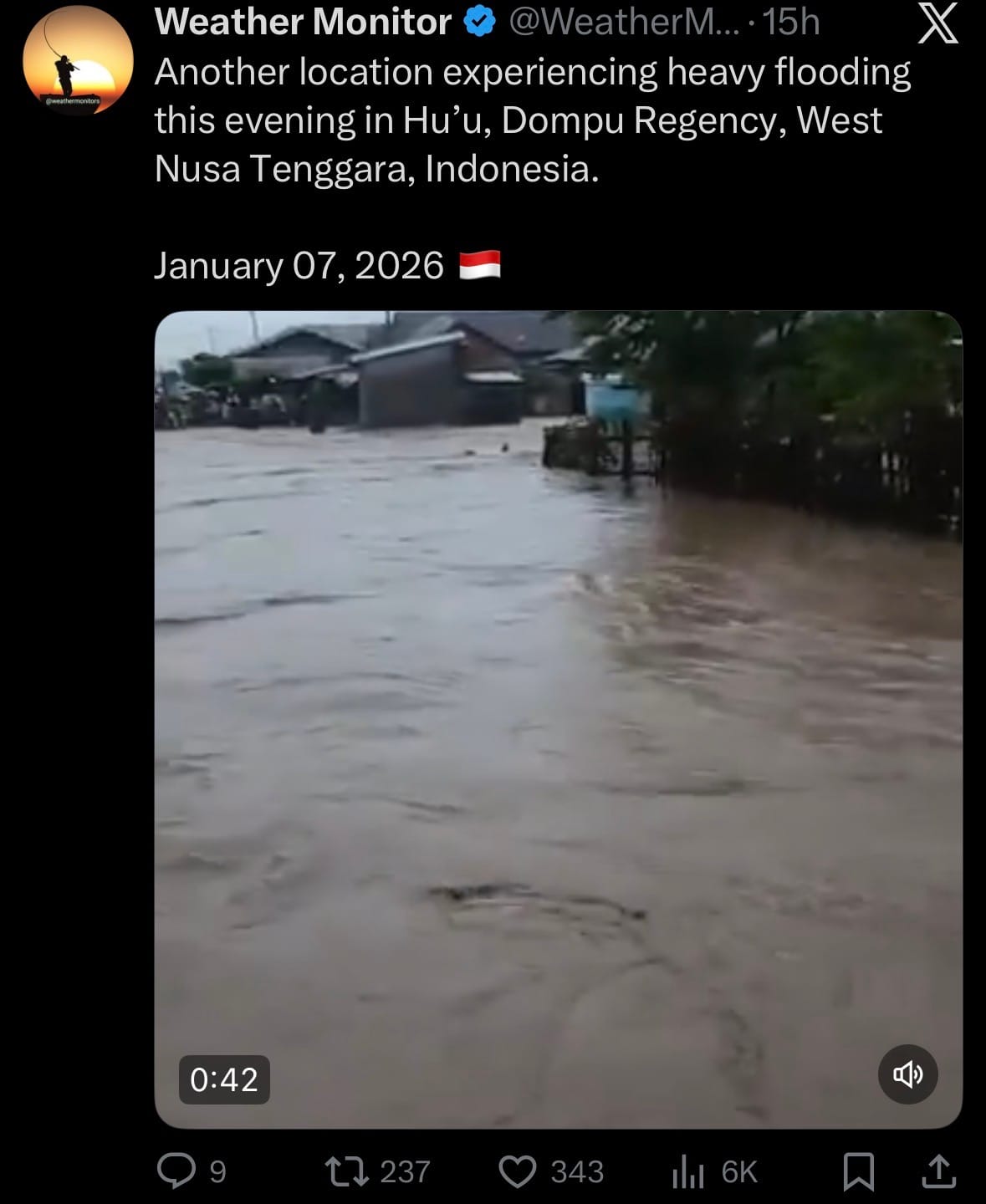
- The flooding resulted from intense downpours overwhelming local rivers and drainage systems in the hilly region, a recurring hazard during Indonesia's peak rainy season influenced by La Niña patterns. Authorities from BNPB (National Disaster Management Agency) and local government deployed pumps and aid, issuing warnings for potential landslides and further flooding in vulnerable coastal and lowland areas of Dompu. This event adds to widespread flooding across Indonesia in early 2026, straining resources amid consecutive weather impacts.
Science & Technology:
- On January 7, 2026, OpenAI announced the launch of ChatGPT Health, a new dedicated section within the ChatGPT app for personalized health-related conversations. Users can securely connect their electronic medical records (via partnerships with providers like Epic Systems) and wellness apps (e.g., Fitbit, Apple Health) to ground responses in individual health data, enabling tailored insights on topics like medication reminders, symptom explanations, or fitness plans. The feature emphasizes privacy through encrypted data handling and user-controlled access, with a waitlist opened for early access to Plus and Enterprise subscribers.

- Designed as a navigational aid rather than a replacement for professional medical advice, ChatGPT Health includes disclaimers urging users to consult healthcare providers for diagnoses or treatments. This release builds on OpenAI's prior integrations like SearchGPT for real-time info, amid growing AI applications in healthcare from competitors like Google's Med-PaLM. It aims to empower users with proactive health management while addressing regulatory concerns over accuracy and liability in sensitive domains.
Statistic:
- Largest public telecom companies by market capitalization:
- 🇨🇳 China Mobile: $229.67B
- 🇺🇸 T-Mobile US: $222.03B
- 🇺🇸 AT&T: $171.39B
- 🇺🇸 Verizon: $169.20B
- 🇯🇵 SoftBank: $162.79B
- 🇩🇪 Deutsche Telekom: $158.76B
- 🇮🇳 Bharti Airtel: $141.33B
- 🇺🇸 Comcast: $109.95B
- 🇨🇳 China Telecom: $84.51B
- 🇯🇵 NTT (Nippon Telegraph & Telephone): $81.98B
- 🇺🇸 American Tower: $79.34B
- 🇯🇵 KDDI: $65.00B
- 🇲🇽 America Movil: $61.16B
- 🇸🇦 Saudi Telecom Company: $56.95B
- 🇸🇬 Singtel: $56.84B
- 🇫🇷 Orange: $44.88B
- 🇦🇪 Emirates Telecom (Etisalat Group): $44.14B
- 🇨🇭 Swisscom: $38.28B
- 🇺🇸 Crown Castle: $37.05B
- 🇺🇸 Ciena: $36.57B
- 🇦🇺 Telstra: $36.14B
- 🇬🇧 Vodafone: $32.97B
- 🇹🇼 Chunghwa Telecom: $32.62B
- 🇺🇸 EchoStar: $32.28B
- 🇭🇰 China Unicom: $31.82B
History:
- Geospatial intelligence, or GEOINT, means understanding the world through location—using maps, imagery, and spatial data to know what is where, how it is changing, and why it matters. At its core, GEOINT turns geography into intelligence. Humans have practiced it for thousands of years, long before the term existed. Early civilizations mapped land to control it: clay tablets in Mesopotamia around 2300 BC recorded property boundaries; Egyptians surveyed the Nile after floods; Romans built detailed road maps to move armies and supplies across Europe, North Africa, and the Middle East. Geography was inseparable from power because terrain shaped trade, war, and governance. By the 18th and 19th centuries, GEOINT took a scientific turn with triangulation, standardized surveying, and national mapping efforts. Accurate maps became state secrets. During the Napoleonic Wars, knowing elevation, river crossings, and road networks often determined victory. The next major leap came from the air. In 1858, the first aerial photograph was taken from a balloon, revealing that land could be measured and analyzed from above. This idea exploded in World War I, when aircraft photography became essential for tracking trenches and artillery. In World War II, photo interpretation became industrialized: analysts used overlapping images to calculate heights, distances, factory output, and even the progress of weapons programs. Geography stopped being static—it became a continuously updated intelligence product.
- The Cold War pushed GEOINT to a planetary scale. After Sputnik in 1957, satellites made it possible to observe Earth globally, repeatedly, and without permission. By the 1960s, reconnaissance satellites were mapping missile sites, airfields, shipyards, and troop movements across the world. This marked a fundamental shift: intelligence was no longer limited by borders. Over time, imagery expanded beyond photographs to include radar, infrared, and later multispectral sensing—allowing analysts to see through clouds, detect heat, and identify materials. In 1996, the term GEOINT was formally defined to unify imagery, maps, terrain data, and spatial analysis into a single discipline. Since the 2000s, GEOINT has exploded beyond government control. Commercial satellites, GPS, drones, LiDAR, maritime tracking systems, and sensor networks now generate constant streams of location-based data. Artificial intelligence automates change detection—spotting new construction, damaged infrastructure, deforestation, ship movements, and environmental shifts at global scale. Today, GEOINT supports military planning, disaster response, climate monitoring, supply-chain security, urban development, and environmental intelligence. Modern GEOINT is not just about knowing where something is—it’s about understanding how physical space, human activity, infrastructure, and the environment interact over time. In practice, GEOINT has become one of the foundational ways humans observe and understand Earth as a living, dynamic system.
Image of the day:

Thanks for reading! Earth is complicated, we make it simple.
- Click below if you’d like to view our free EARTH WATCH globe:
- Download our mobile app:


Click below to view our previous newsletters:
Support/Suggestions Email:
earthintelligence@earthintel.news