Tuesday☕️


Trending:
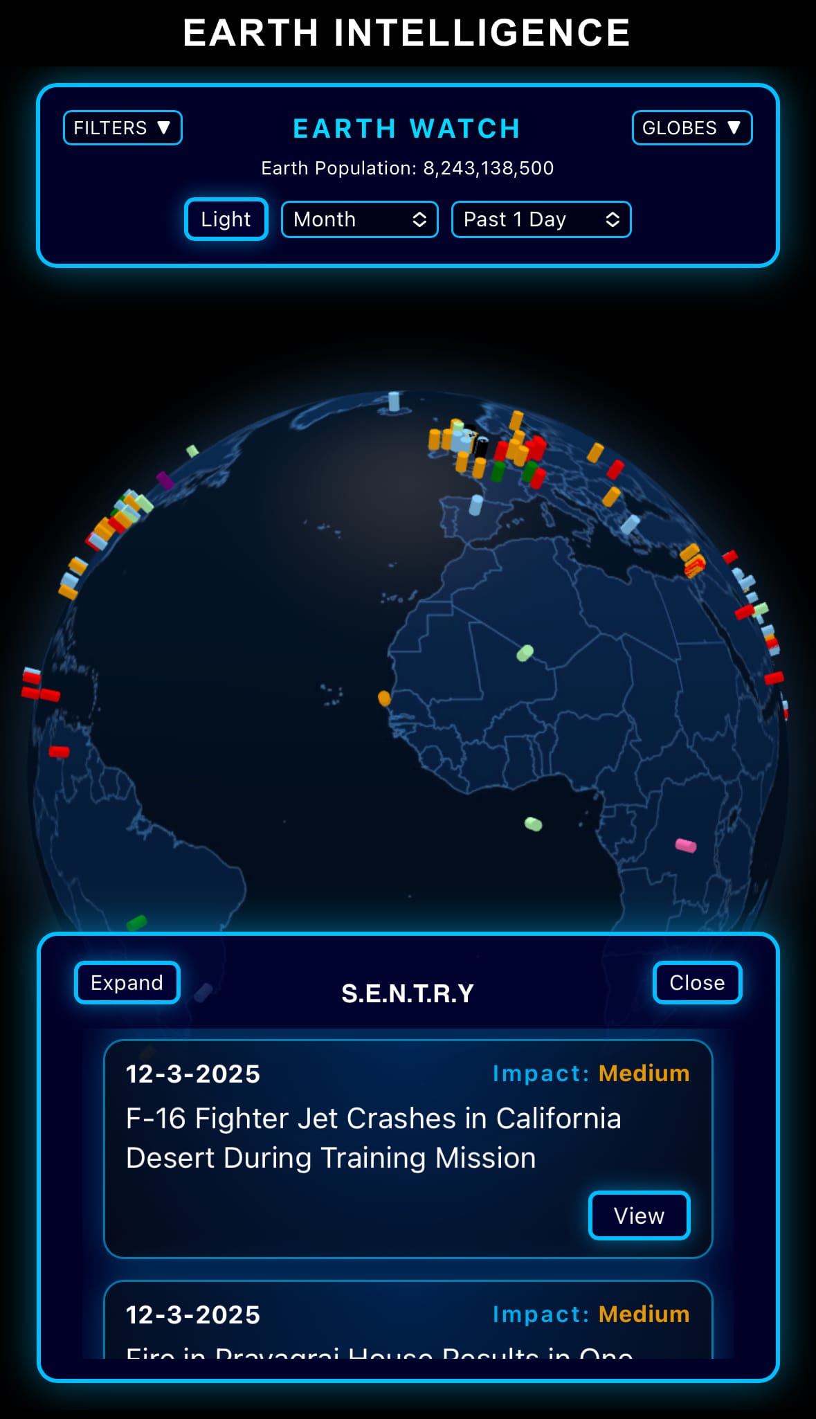
- On January 19, 2026, a high-speed passenger train derailed and collided with an oncoming train near Adamuz in Córdoba province, Andalusia, southern Spain, killing at least 40 people and injuring more than 150, according to regional authorities and emergency services. The accident occurred Sunday evening when the Madrid-bound train jumped the tracks and struck another service head-on. Rescue operations continued into the night with firefighters, police, and medical teams working at the site, amid concerns the death toll could rise further as debris was cleared.

- Spanish Prime Minister Pedro Sánchez declared three days of national mourning and expressed solidarity with the victims' families. Authorities are investigating a possible broken rail or track failure as the primary cause, with initial reports ruling out human error or weather conditions. This is Spain's deadliest rail disaster since the 2013 Santiago de Compostela derailment, which killed 81 people. Emergency services described the scene as chaotic with multiple carriages overturned or crushed, and hospitals in Córdoba and nearby cities were placed on high alert to treat the injured.
Economics & Markets:
- Yesterday’s U.S. stock market:

- Yesterday’s commodity market:

- Yesterday’s crypto market:

Geopolitics & Military Activity:
- On January 19, 2026, reports emerged of heightened U.S. military air activity over Hasakah and surrounding areas in northeastern Syria, including low-level fighter jet patrols, reconnaissance flights, and helicopter movements observed by local sources and open-source flight trackers. Syrian government forces were photographed near road signs pointing to Hasakah, indicating continued ground presence in the province despite the January 18 ceasefire agreement between Damascus and the Syrian Democratic Forces (SDF). The ceasefire included provisions for gradual SDF integration into Syrian state institutions and government control over key infrastructure such as oil fields, gas facilities, and border crossings.
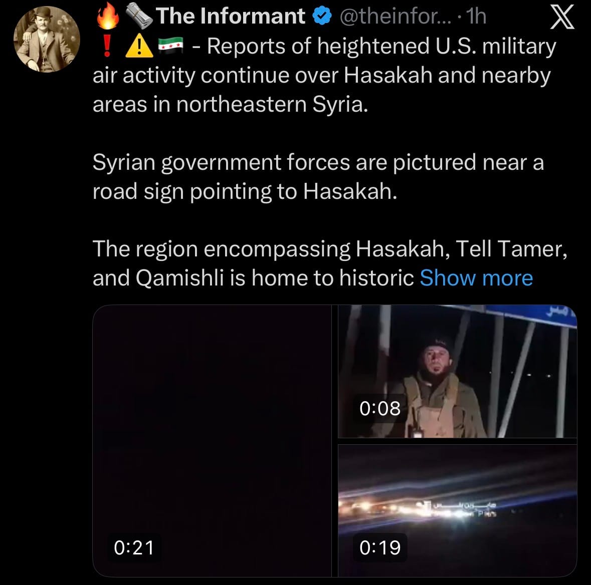
- However, both sides accused each other of violations within 24 hours. Renewed clashes were reported in parts of Hasakah province, with Syrian forces advancing in some areas while the SDF maintained control over significant portions, including the city of Qamishli. Security incidents occurred near facilities holding ISIS detainees, raising concerns about potential escapes or attacks. The region—home to historic Assyrian and Armenian Christian communities as well as Arab, Kurdish, and other populations—remains tense, with U.S. forces conducting overflights to monitor the situation and deter escalation or ISIS resurgence.
Environment & Weather:
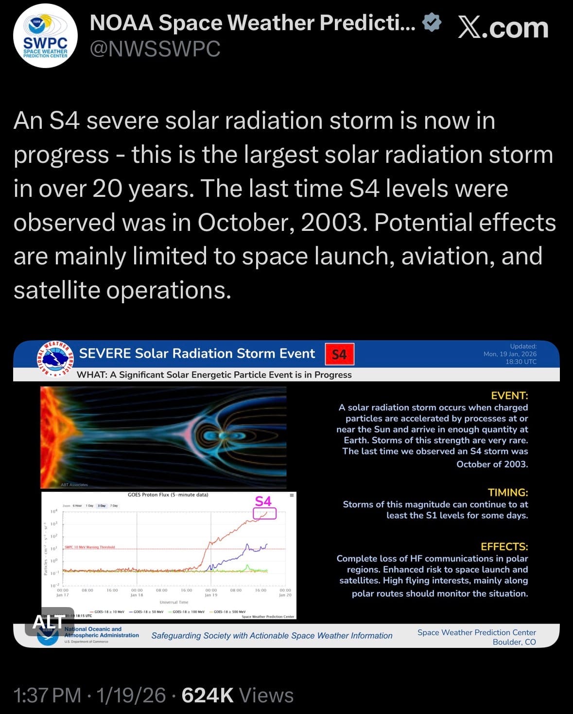
- On January 19, 2026, a powerful geomagnetic storm (G4-level activity) triggered by recent solar flares made the northern lights (aurora borealis) visible unusually far south across much of the United States, including Tennessee. The storm pushed the auroral oval southward, creating opportunities for sightings in the Tennessee Valley and other southern states like Alabama, Kentucky, and parts of the Southeast. Forecasts from NOAA and space weather experts indicated the best viewing window was overnight into early January 20, with clearer skies in rural or dark-sky areas away from city lights.
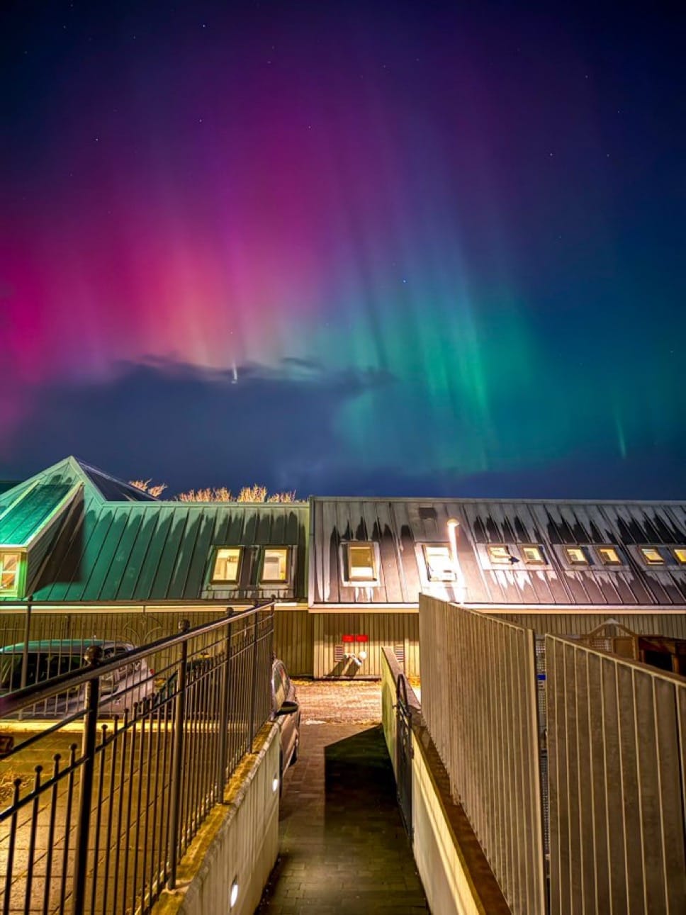
- In Tennessee, the aurora was expected to appear as a faint green or red glow low on the northern horizon rather than the vivid dancing lights seen farther north, due to the state's southern latitude. No widespread confirmed sightings were immediately reported from the state, but conditions were favorable in areas with low light pollution (e.g., rural East or West Tennessee). The event is considered rare for the region, driven by heightened solar activity during the ongoing solar cycle peak.
Space:
- On January 19, 2026, China successfully launched the SatNet LEO Group 19 mission using a Long March-12 carrier rocket from the Hainan commercial spacecraft launch site (Wenchang Space Launch Site) in southern China's Hainan Province. The rocket deployed 9 Low Earth Orbit communication satellites for the state-owned GuoWang (SatNet) constellation, operated by the China Satellite Network Group.
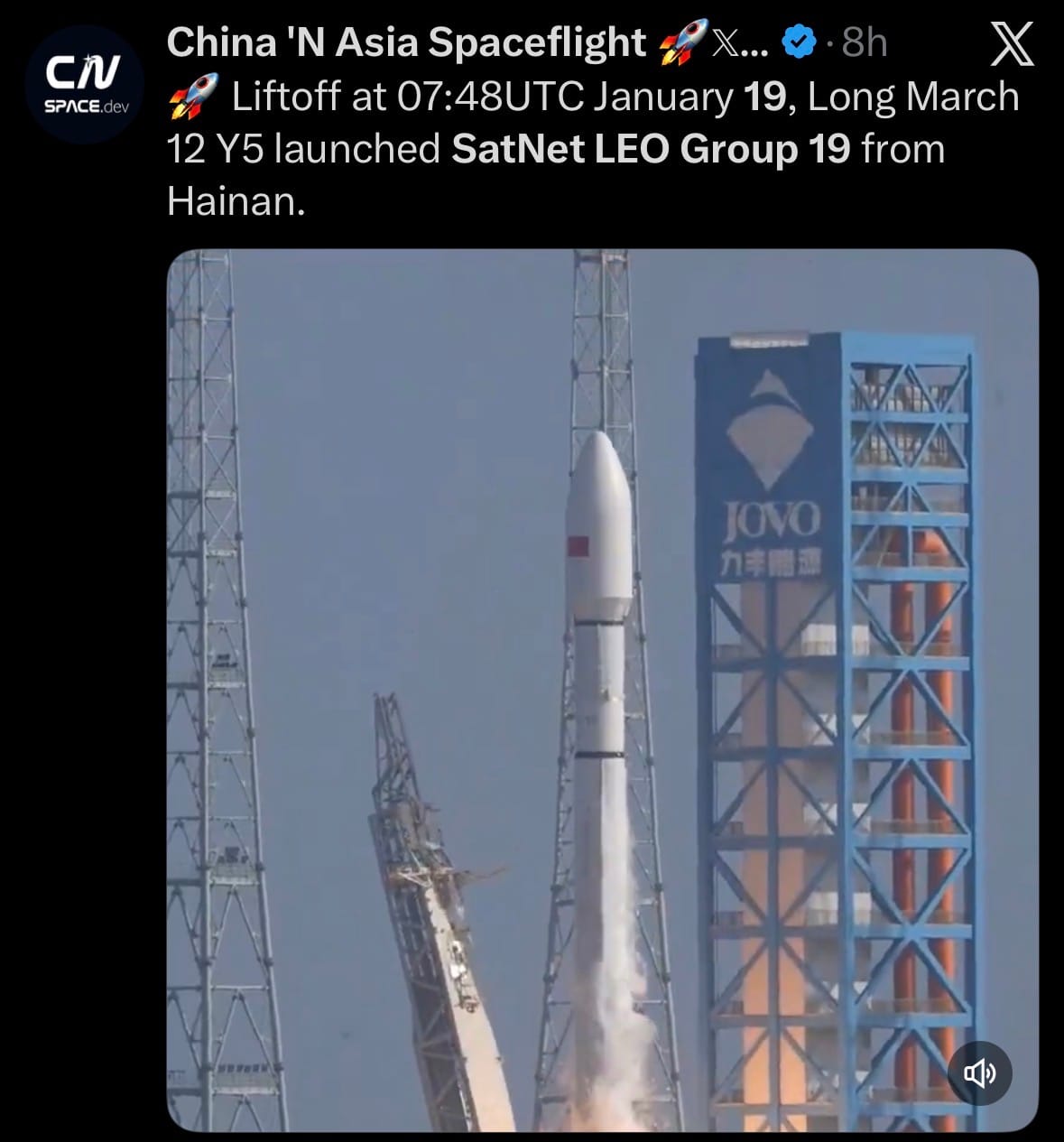
- The launch was confirmed by Chinese state media, with the satellites successfully inserted into their preset polar orbit and no anomalies reported. These satellites continue expanding the GuoWang megaconstellation, planned to eventually consist of 13,000 satellites to provide global high-speed broadband internet, positioning it as a direct competitor to systems like Starlink. Group 19 further improves coverage in polar and mid-latitude regions, supporting both commercial connectivity and strategic national objectives.
Statistic:
- Largest public banking companies on Earth by market capitalization:
- 🇺🇸 JPMorgan Chase — $850.62 B
- 🇺🇸 Bank of America — $386.81 B
- 🇨🇳 ICBC — $362.79 B
- 🇨🇳 Agricultural Bank of China — $355.86 B
- 🇨🇳 China Construction Bank — $335.12 B
- 🇺🇸 Morgan Stanley — $300.52 B
- 🇺🇸 Goldman Sachs — $291.21 B
- 🇬🇧 HSBC — $283.34 B
- 🇺🇸 Wells Fargo — $277.43 B
- 🇨🇳 Bank of China — $247.11 B
- 🇨🇦 Royal Bank of Canada — $237.68 B
- 🇯🇵 Mitsubishi UFJ Financial — $216.46 B
- 🇺🇸 Citigroup — $211.20 B
- 🇺🇸 Charles Schwab — $188.45 B
- 🇪🇸 Santander — $180.85 B
- 🇦🇺 Commonwealth Bank — $169.51 B
- 🇮🇳 HDFC Bank — $167.43 B
- 🇨🇦 Toronto Dominion Bank — $158.97 B
- 🇺🇸 Capital One — $152.93 B
- 🇨🇳 CM Bank — $151.00 B
- 🇨🇭 UBS — $149.30 B
- 🇪🇸 Banco Bilbao Vizcaya Argentaria (BBVA) — $138.58 B
- 🇯🇵 Sumitomo Mitsui Financial Group — $136.79 B
- 🇸🇬 DBS Group — $128.77 B
- 🇮🇹 UniCredit — $125.23 B
History:
- Underwater surveillance starts with a basic physical reality: the ocean hides objects from sight, but it carries sound extremely well. Long before modern submarines, navies understood that the undersea domain could not be controlled visually. Early concepts were simple and human-driven. In the early 1900s, as submarines began to appear as viable weapons, crews experimented with primitive hydrophones—essentially underwater microphones—to listen for propellers. World War I (1914–1918) forced the first organized undersea surveillance efforts as German U-boats threatened global shipping. Passive listening stations, patrol craft, and early escort tactics emerged, but detection was unreliable and reactive. The interwar period produced the first real technological breakthrough: active sonar (often referred to historically as ASDIC), which allowed ships to send sound pulses and listen for echoes, transforming underwater detection from guesswork into an engineered process. World War II (1939–1945) then industrialized underwater surveillance into a full system: escort ships with sonar, aircraft deploying sonobuoys to extend listening range, coordinated convoy defense, and the first wide-area undersea sensing concepts. By the end of the war, navies understood that underwater dominance depended not on a single ship or weapon, but on persistent sensing, cueing, and coordinated response across platforms.
- The Cold War elevated underwater surveillance from regional defense to planetary intelligence, and this is where the United States set the defining standard. As nuclear submarines emerged—capable of long endurance and deep, quiet operation—the U.S. recognized that long-range passive acoustics were the only viable solution. Research beginning in the late 1940s led to seabed hydrophone arrays placed in deep water, exploiting the ocean’s sound channel to detect submarines at extraordinary distances. These fixed arrays were linked by undersea cables to shore-based processing centers, allowing analysts to track submarine movements across entire ocean basins. Over time, this evolved into a broader ecosystem: fixed seabed sensors, towed-array sonar on surface ships and submarines, dedicated surveillance vessels towing extremely long passive arrays, and libraries of acoustic “fingerprints” used to classify submarines by class and even individual hull. In 1985, these capabilities were formally unified under the Integrated Undersea Surveillance System (IUSS), reflecting a shift from isolated sensors to a fused intelligence network. NATO allies built complementary systems—especially in the North Atlantic and Arctic—while the Soviet Union developed its own undersea detection and bastion-defense concepts to protect strategic submarines. This era defined the core undersea competition: quieter submarines versus better listening, fought almost entirely in silence.
- Today, underwater surveillance is entering a new phase driven by autonomy, persistence, and infrastructure protection. Modern submarines are extraordinarily quiet, making detection increasingly difficult with traditional methods alone. In response, nations are building distributed undersea sensor networks rather than relying on a few exquisite systems. The United States remains the most mature undersea surveillance power, combining decades of fixed and mobile acoustic systems with advanced submarines, maritime patrol aircraft, data fusion, and now unmanned underwater vehicles (UUVs) and autonomous surface vessels acting as sensor carriers. China is rapidly expanding regional undersea awareness through seabed sensing concepts, civil-military ocean observatories, unmanned systems, and integration with surface and air surveillance to control near-sea approaches. Russia emphasizes undersea monitoring around strategic bastion areas, Arctic routes, and critical infrastructure, pairing fixed sensing with submarines and patrol assets. Across NATO and other maritime powers, the trend is the same: autonomous gliders acting as mobile listeners, unmanned surface vessels towing arrays, selective low-frequency active sonar, and heavy use of AI to detect patterns in massive acoustic datasets. Underwater surveillance now extends beyond submarines to include protection of fiber-optic cables, pipelines, offshore energy platforms, and seabed infrastructure. The future of the undersea domain is not a single dominant platform, but a layered, intelligent network—fixed sensors, mobile arrays, crewed ships and submarines, and autonomous drones—turning the ocean from a hiding place into a contested, continuously monitored battlespace.
Image of the day:

Thanks for reading! Earth is complicated, we make it simple.
- Click below if you’d like to view our free EARTH WATCH globe:
- Download our mobile app:


Click below to view our previous newsletters:

Support/Suggestions Email:
earthintelligence@earthintel.news