Wednesday☕️


Trending:
- On December 30, 2025, U.S. Central Command (CENTCOM) announced that U.S. and partner forces conducted 11 ground missions in Syria from December 20-29, killing at least seven ISIS operatives, capturing nearly 18 others (totaling nearly 25 militants affected), and destroying four weapons caches. These raids followed the large-scale Operation Hawkeye Strike launched on December 19, where U.S. and Jordanian forces—using dozens of fighter aircraft, attack helicopters, and artillery—hit over 70 ISIS targets across central Syria with more than 100 precision munitions, degrading infrastructure and weapons sites.

- The operations reflect an intensified U.S.-led campaign in 2025 against ISIS threats, with the command noting at least 11 ISIS-inspired plots or attacks targeting the United States this year. Over the past 12 months, coalition forces in Syria have detained more than 300 suspected terrorists and killed over 20. CENTCOM Commander Adm. This sustained pressure demonstrates the coalition's proactive approach to countering persistent ISIS remnants in Syria, potentially disrupting rebuilding efforts amid broader Middle East instability.
Economics & Markets:
- Yesterday’s U.S. stock market:

- Yesterday’s commodity market:

- Yesterday’s crypto market:

Geopolitics & Military Activity:
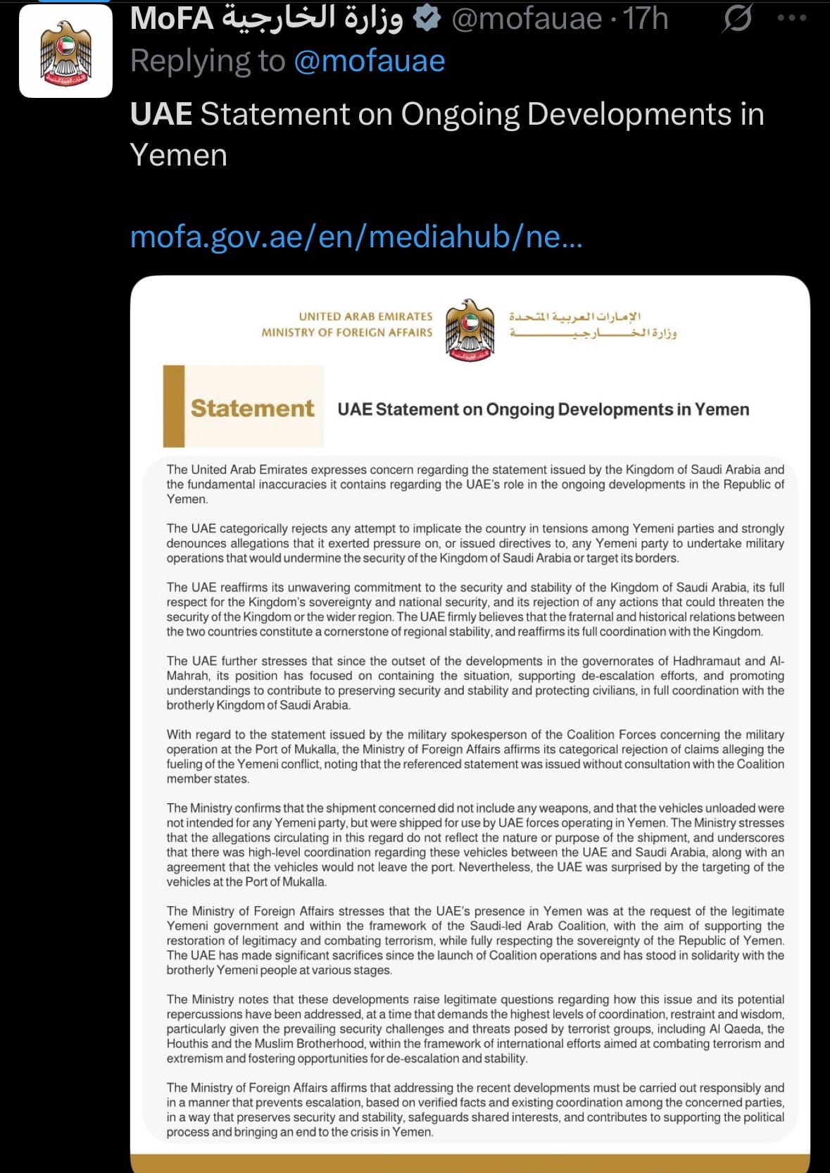
- On December 30, 2025, the United Arab Emirates announced the withdrawal of its remaining counterterrorism personnel from Yemen—the last UAE forces in the country since scaling back operations in 2019—amid rising tensions with Saudi Arabia. The move followed Saudi-led coalition airstrikes on vehicles and equipment at Mukalla port in Hadramaut province, which Saudi authorities described as neutralizing an unauthorized shipment intended for the UAE-supported Southern Transitional Council (STC) separatists. The UAE rejected the claim, asserting the vehicles belonged to its own forces and that the transfer had been coordinated with Saudi Arabia in advance; the strikes caused no casualties.

- The incident arose from recent STC military advances in resource-rich southern Yemen, which Saudi Arabia views as challenging national unity and the authority of the internationally recognized Yemeni government. Saudi Arabia supported a demand from Yemen's Presidential Leadership Council for UAE forces to depart within 24 hours and terminated a defense agreement with the UAE. This public disagreement between the two Gulf states—longtime allies in Yemen's conflict—highlights their differing priorities: Saudi Arabia favors a unified Yemen, while the UAE has backed southern separatists.
Environment & Weather:
- On December 30, 2025, heavy rainfall triggered severe flooding and landslides in Nagari Saniang Baka, Solok Regency, West Sumatra, Indonesia. Floodwaters and debris flows inundated residential areas, damaged homes, swept away bridges, and disrupted roads, forcing evacuations of dozens of families to temporary shelters. Local authorities reported significant material losses, with no immediate fatalities but several residents injured or missing amid ongoing search efforts.

- The event followed prolonged downpours overwhelming rivers and slopes in the mountainous region, a common hazard during Indonesia's rainy season. Emergency teams deployed pumps and heavy equipment for rescue and cleanup, while warnings remain for potential further landslides and flooding in vulnerable districts.
California Earthquake:
- On December 31, 2025 (late evening December 30 PST), a magnitude 5.3 earthquake struck approximately 9 miles (14 km) northwest of Susanville in Lassen County, Northern California, at 9:49 p.m. local time (05:49 UTC on December 31). The shallow quake (depth ~3-5 miles) triggered the ShakeAlert early warning system, sending alerts to mobile devices in affected areas seconds before strong shaking arrived.
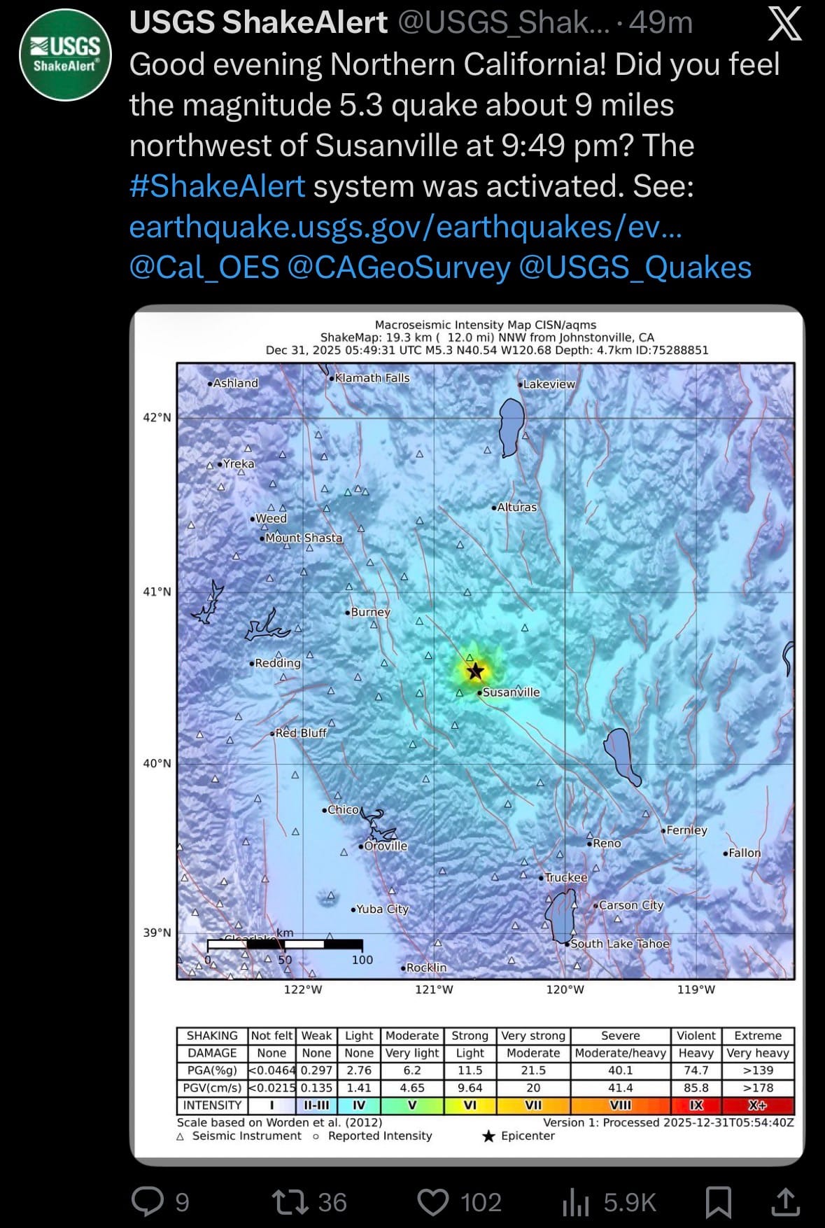
- Reports indicate moderate shaking near the epicenter, with lighter tremors felt in surrounding regions including parts of Nevada (e.g., Reno); no immediate injuries or significant damage were reported. This quake underscores Northern California's ongoing exposure to moderate seismic events in tectonically active zones like the Walker Lane.
Space:
- On December 31, 2025, China successfully launched the Shijian-29A and Shijian-29B experimental satellites aboard a Long March 7A rocket from the Wenchang Space Launch Site in Hainan Province. Liftoff occurred at 6:40 a.m. Beijing time (22:40 UTC on December 30), with the satellites entering their preset orbit shortly after. Developed by the Shanghai Academy of Spaceflight Technology and Innovation Academy for Microsatellites (Chinese Academy of Sciences), the pair will conduct new technology verification tests related to space target detection.
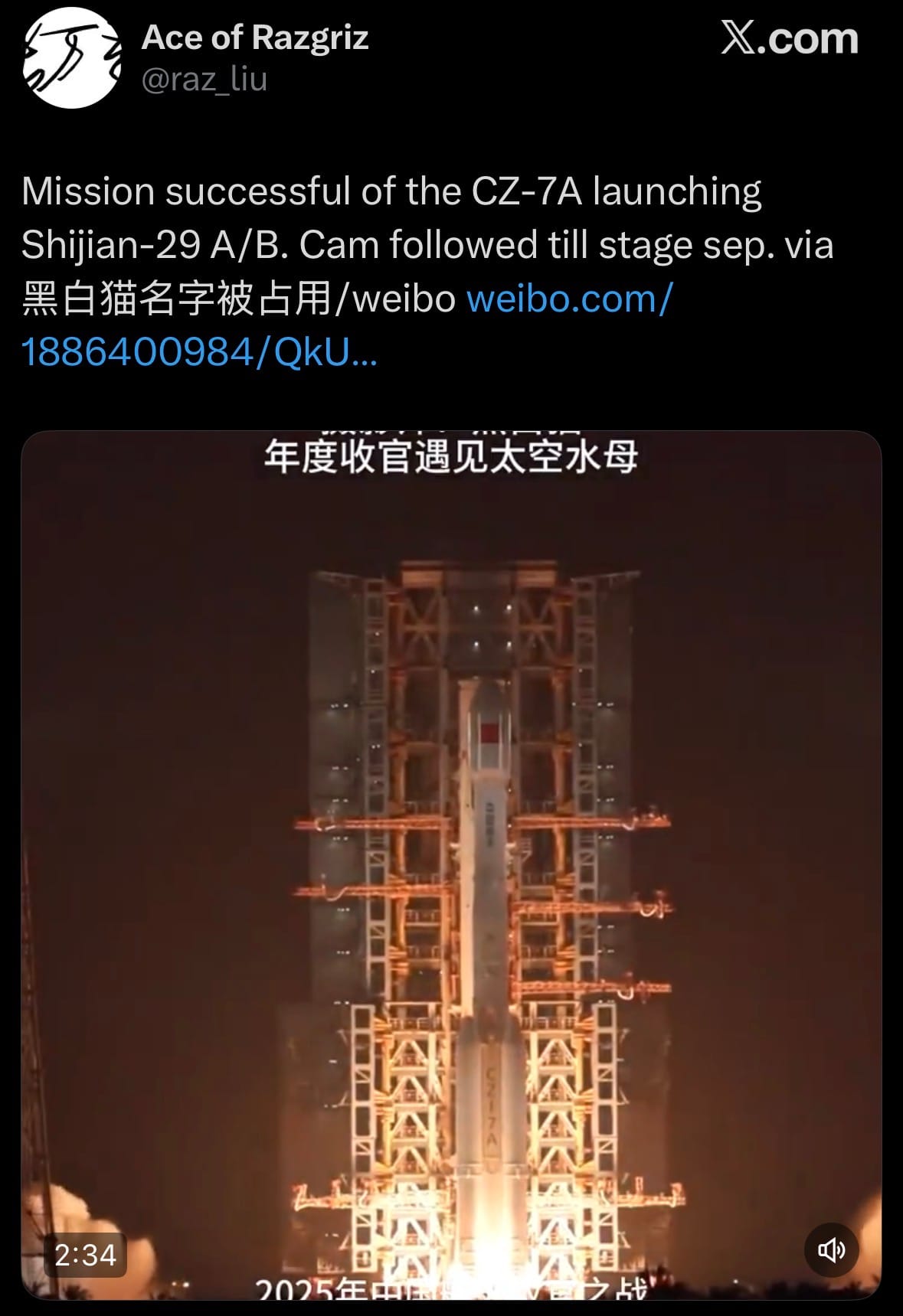
- These Shijian ("Practice") series satellites support on-orbit sensing, tracking, and characterization of space objects, advancing China's space situational awareness capabilities through coordinated observations and potential formation-flying experiments. The focus on space target detection highlights growing emphasis on countering threats like debris and adversarial satellites in an increasingly congested domain.
Statistic:
- Largest public companies on Earth by market capitalization:
- 🇺🇸 NVIDIA: $4.566T
- 🇺🇸 Apple: $4.052T
- 🇺🇸 Alphabet (Google): $3.797T
- 🇺🇸 Microsoft: $3.623T
- 🇺🇸 Amazon: $2.485T
- 🇺🇸 Meta Platforms: $1.678T
- 🇺🇸 Broadcom: $1.658T
- 🇹🇼 TSMC: $1.553T
- 🇸🇦 Saudi Aramco: $1.523T
- 🇺🇸 Tesla: $1.511T
- 🇺🇸 Berkshire Hathaway: $1.086T
- 🇺🇸 Eli Lilly: $967.94B
- 🇺🇸 Walmart: $892.32B
- 🇺🇸 JPMorgan Chase: $889.32B
- 🇨🇳 Tencent: $696.27B
- 🇺🇸 Visa: $682.45B
- 🇺🇸 Oracle: $566.60B
- 🇰🇷 Samsung: $556.45B
- 🇺🇸 Mastercard: $521.99B
- 🇺🇸 Exxon Mobil: $515.81B
- 🇺🇸 Johnson & Johnson: $498.50B
- 🇺🇸 Palantir: $431.02B
- 🇳🇱 ASML: $416.14B
- 🇺🇸 Bank of America: $409.45B
- 🇺🇸 AbbVie: $406.03B
History:
- LiDAR—short for Light Detection and Ranging—begins as a physics idea long before it becomes a practical sensing system. Its conceptual roots trace back to early 20th-century optics and radar theory, but LiDAR only becomes feasible after the invention of the laser in 1960. Almost immediately, scientists realize that laser pulses could be used like radar, but with light instead of radio waves. In 1961–1963, the first experimental LiDAR systems are built to measure atmospheric properties such as clouds, aerosols, and pollution by timing how long laser pulses take to reflect back to a sensor. The U.S. military and space agencies are early drivers: during the 1960s–1970s, LiDAR is used to study the upper atmosphere, track missiles, and support lunar research. A major milestone comes in 1971, when NASA uses laser altimetry on the Apollo 15 mission to map the Moon’s surface, proving LiDAR’s value for precise distance measurement from aircraft and spacecraft. Through the 1980s and 1990s, advances in solid-state lasers, photodetectors, and GPS allow airborne LiDAR to mature, enabling high-resolution topographic mapping that far surpasses traditional surveying methods. For the first time, landscapes could be measured in three dimensions at scale, even through forest canopies.
- In the 2000s and 2010s, LiDAR expands from a specialized scientific tool into a core sensing technology across civilian, commercial, and military domains. Airborne and terrestrial LiDAR revolutionize geospatial intelligence, archaeology (revealing lost cities beneath jungles), flood modeling, forestry, urban planning, and infrastructure inspection. Space-based LiDAR missions—such as NASA’s ICESat (2003) and GEDI (2018)—extend the technology to global measurements of ice sheets, forests, and carbon storage. At the same time, miniaturization and cost reduction push LiDAR into real-time systems. Autonomous vehicles adopt LiDAR for precise 3D perception, robotics use it for navigation and mapping, and smartphones begin integrating simplified LiDAR sensors for depth sensing and augmented reality. Militarily, LiDAR supports targeting, terrain analysis, drone navigation, camouflage detection, and environmental awareness, often fused with radar, imagery, and AI analytics. Modern LiDAR systems now leverage solid-state designs, single-photon detection, machine learning, and sensor fusion, producing dense, real-time 3D representations of the world. Today, LiDAR is less about measuring distance and more about building dynamic digital twins of physical reality—capturing terrain, structures, vegetation, and motion with centimeter-level precision. From early laser experiments to planetary-scale mapping and autonomous perception, LiDAR has become a foundational technology for understanding and navigating the physical world in three dimensions.
Image of the day:

Thanks for reading! Earth is complicated, we make it simple.
- Click below if you’d like to view our free EARTH WATCH globe:
- Download our mobile app:


Click below to view our previous newsletters:

Support/Suggestions Email:
earthintelligence@earthintel.news