Wednesday☕️


Trending:
- On January 6, 2026, U.S. President Donald Trump announced via Truth Social that Venezuelan interim authorities, following the U.S.-led capture of former President Nicolás Maduro in Operation Absolute Resolve, would transfer between 30 and 50 million barrels of sanctioned crude oil to the United States. The oil, described as high-quality Venezuelan heavy crude from state-owned PDVSA stockpiles, would be redirected to U.S. refineries under a deal facilitated by the interim government led by Vice President Delcy Rodríguez. Trump stated this would help offset U.S. energy costs amid global market volatility, framing it as part of broader efforts to dismantle "narco-terrorist" networks and recover assets tied to alleged illicit activities, with the transfer expected to begin within weeks via seized or rerouted tankers.
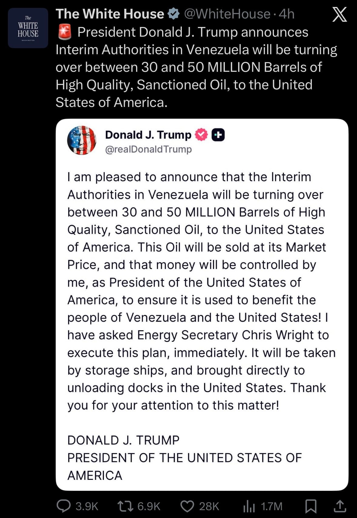
- The announcement drew mixed reactions: Venezuelan opposition figures and some U.S. allies praised it as a step toward economic recovery and weakening Maduro's influence, while critics in Venezuela and internationally condemned it as resource exploitation violating sovereignty. Allies like Russia, China, and Cuba called it "theft" and urged UN intervention, with oil prices dipping slightly on news of increased supply. European leaders expressed concern over legality under international law, and analysts noted potential impacts on global energy markets, including reduced Venezuelan exports to Asia. This move highlights the U.S. administration's strategy to leverage captured assets for domestic benefit while navigating diplomatic fallout from the intervention.
Economics & Markets:
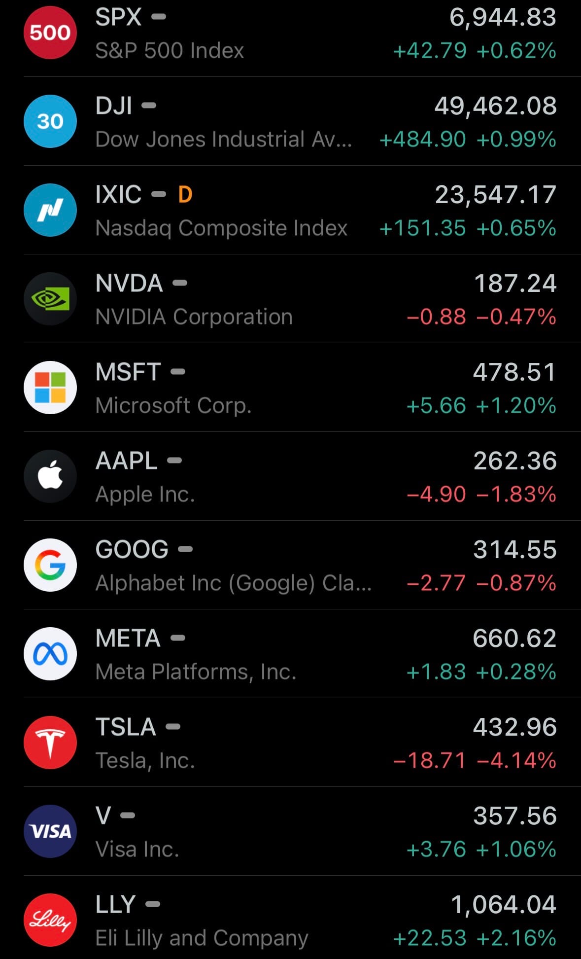
- Yesterday’s U.S. stock market:
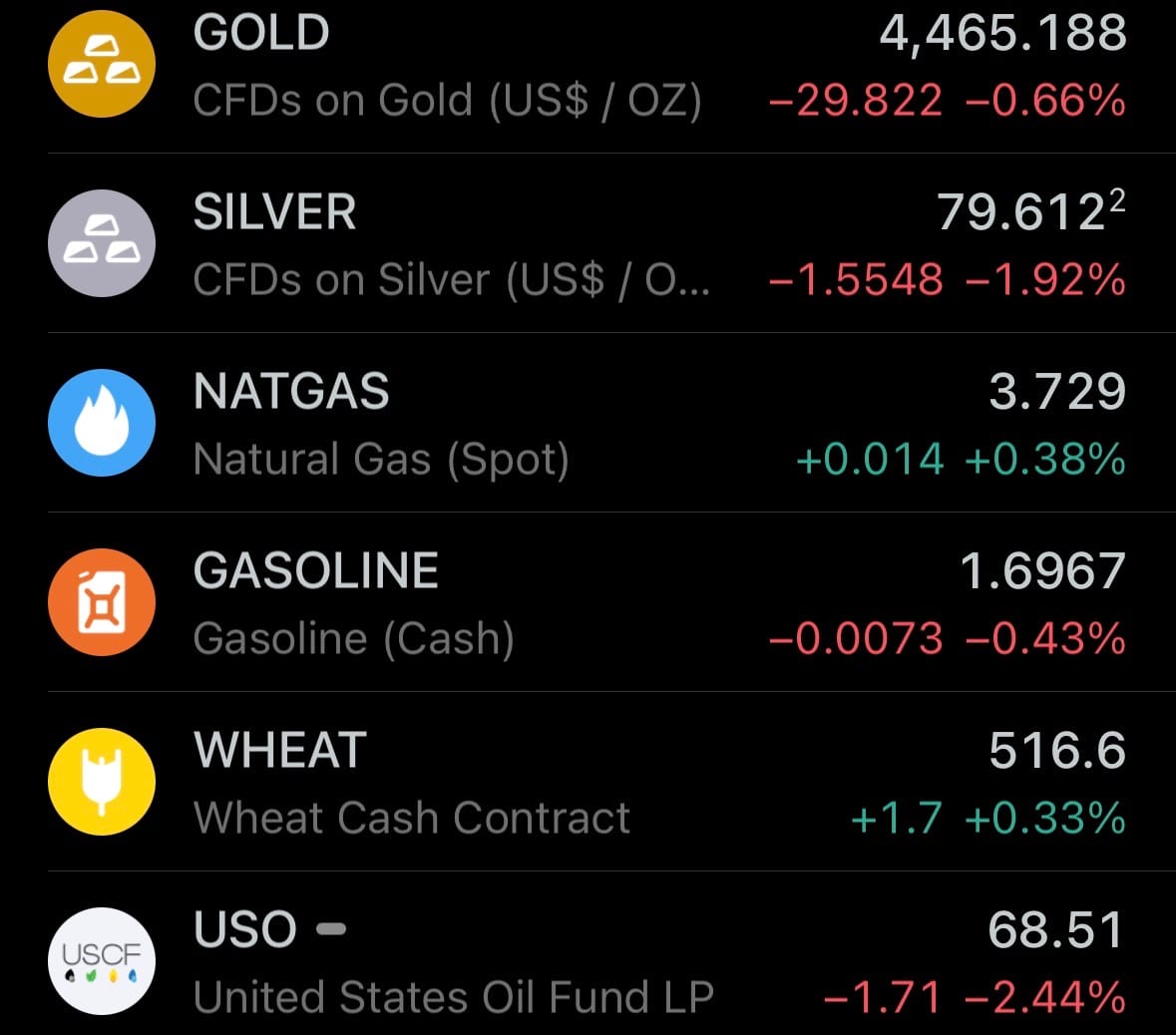
- Yesterday’s commodity market:
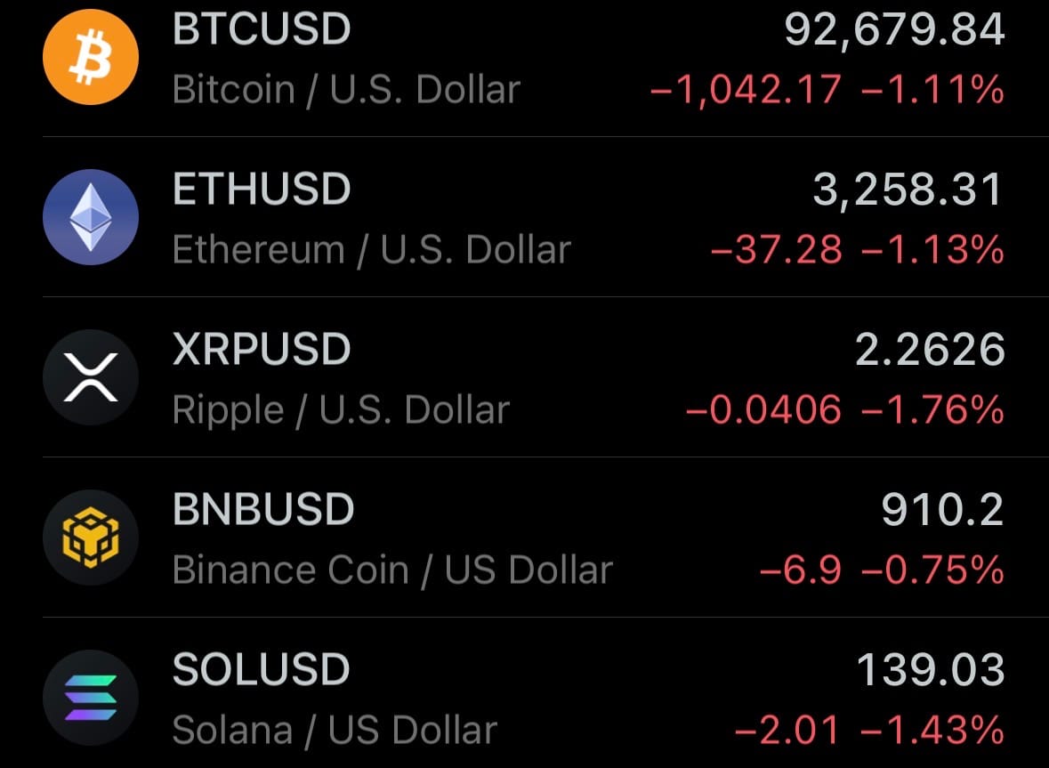
- Yesterday’s crypto market:
Geopolitics & Military Activity:
- On January 7, 2026, the aging oil tanker Marinera (formerly Bella 1) continued its voyage toward Murmansk, Russia, via the North Sea, positioned approximately 300 miles south of Iceland. Russia deployed a Kilo-class submarine and surface naval assets to escort the empty vessel after it changed name, painted a Russian flag on its hull, and re-registered under Russian flag in late December 2025. The move followed a failed U.S. Coast Guard boarding attempt in the Caribbean, where the crew repelled the operation. The tanker carries a U.S. judicial seizure warrant for allegedly transporting sanctioned Iranian oil linked to U.S.-designated terrorist groups.
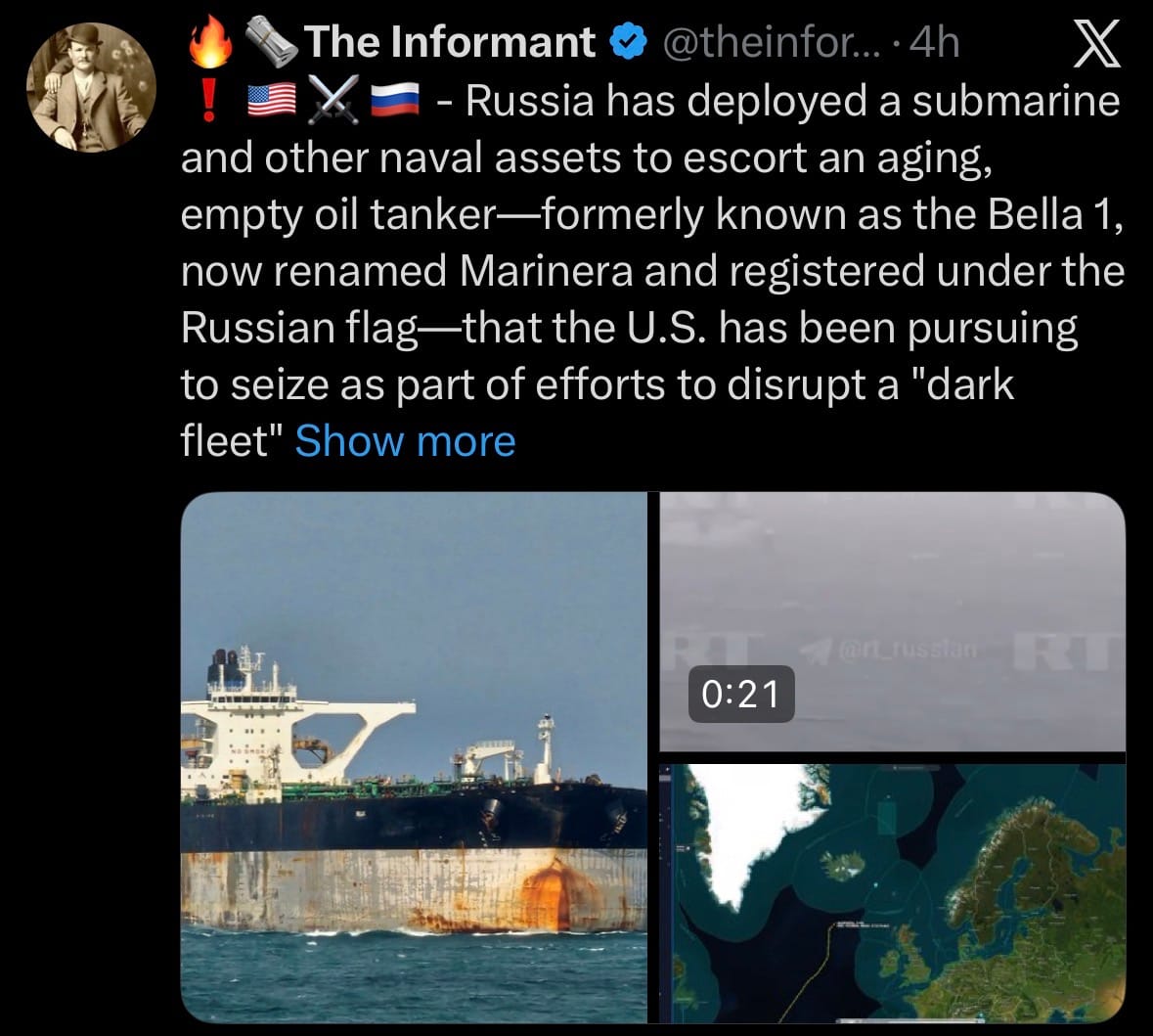
- Russia's Foreign Ministry formally requested the U.S. cease pursuit, calling it unlawful, while rejecting accusations of operating a "dark fleet." U.S. Southern Command confirmed ongoing surveillance by Coast Guard assets but has not attempted further interdiction. Experts note the Russian registration provides flag-state protection under international maritime law, significantly complicating any U.S. boarding without Russian consent, which could risk escalation. This incident underscores heightened U.S.-Russia maritime tensions amid sanctions enforcement and broader geopolitical frictions, including over Ukraine and Venezuela. The case illustrates challenges in countering shadow fleets of over 1,000 older, obscurely owned vessels used for evading oil sanctions.
Environment & Weather:
- On January 7, 2026, a magnitude 6.7 earthquake struck at 11:02 a.m. local time, with its epicenter located 76 km northeast of Manay in Davao Oriental province on Mindanao island, Philippines. The shallow quake (depth approximately 10-15 km) caused intense shaking—up to intensity VII on the PHIVOLCS scale—in nearby towns including Manay, Tarragona, and parts of Davao Oriental and Davao de Oro. Moderate shaking was felt across much of southeastern Mindanao, including Davao City, where high-rise buildings swayed and residents evacuated. No tsunami warning was issued, as the event did not meet threshold criteria.
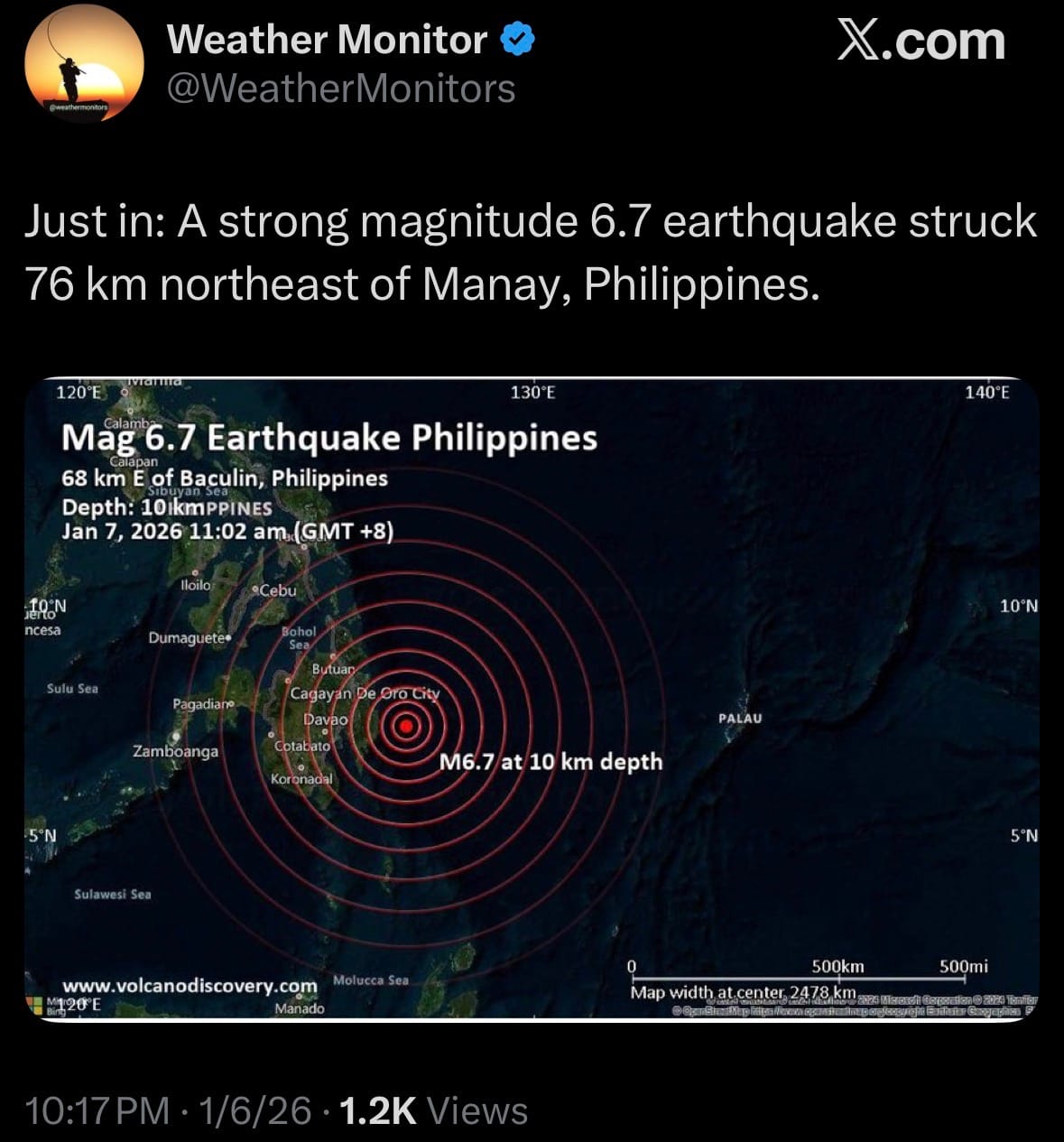
- Initial reports indicated structural damage to homes, roads, and schools in rural areas near the epicenter, with landslides blocking sections of highways. At least two injuries were confirmed from falling debris, and power outages affected several municipalities; no fatalities were immediately reported. Emergency teams from PHIVOLCS, local governments, and the National Disaster Risk Reduction and Management Council conducted assessments, urging residents to prepare for aftershocks (several M4.5-5.2 events followed within hours). The Philippines, situated on the Pacific Ring of Fire, experiences frequent seismic activity, and this quake highlights ongoing risks in the tectonically active eastern Mindanao fault zone.
Statistic:
- Largest public companies on Earth by market capitalization:
- 🇺🇸 NVIDIA: $4.558T
- 🇺🇸 Apple: $3.893T
- 🇺🇸 Alphabet (Google): $3.797T
- 🇺🇸 Microsoft: $3.556T
- 🇺🇸 Amazon: $2.575T
- 🇹🇼 TSMC: $1.698T
- 🇺🇸 Meta Platforms: $1.665T
- 🇺🇸 Broadcom: $1.629T
- 🇸🇦 Saudi Aramco: $1.511T
- 🇺🇸 Tesla: $1.439T
- 🇺🇸 Berkshire Hathaway: $1.076T
- 🇺🇸 Eli Lilly: $953.86B
- 🇺🇸 JPMorgan Chase: $920.09B
- 🇺🇸 Walmart: $911.61B
- 🇨🇳 Tencent: $732.41B
- 🇺🇸 Visa: $690.05B
- 🇰🇷 Samsung: $645.89B
- 🇺🇸 Oracle: $556.66B
- 🇺🇸 Mastercard: $524.63B
- 🇺🇸 Exxon Mobil: $516.06B
- 🇺🇸 Johnson & Johnson: $493.39B
- 🇳🇱 ASML: $482.15B
- 🇺🇸 Palantir: $428.32B
- 🇺🇸 Bank of America: $424.04B
- 🇺🇸 AbbVie: $395.77B
History:
- The history of shipping transponders starts with a simple problem: ships needed a reliable way to know where other ships were, especially as global trade intensified and vessels grew larger and faster. For most of maritime history, awareness depended on visual signals—flags, lights, horns—and later voice radio. In the early 20th century, radio allowed ships to report positions manually, but this relied on human accuracy and constant communication. As shipping volumes exploded after World War II, collisions and environmental disasters exposed the limits of this approach. A major turning point came after incidents like the 1989 Exxon Valdez oil spill, which highlighted how little real-time visibility authorities had over ship movements. In the 1990s, maritime regulators began pushing for automated, standardized position reporting. This effort culminated in the Automatic Identification System (AIS), developed in the late 1990s and mandated internationally in the early 2000s. AIS combines GPS positioning with a VHF radio transponder that automatically broadcasts a ship’s identity, position, speed, and course at regular intervals. The core idea is simple: ships continuously announce themselves so nearby vessels and coastal authorities can avoid collisions and manage traffic safely. Over time, AIS expanded from ship-to-ship use to shore-based monitoring and then to satellites, turning it into a global tracking system for compliant vessels.
- As AIS coverage expanded, maritime tracking became a form of real-time global intelligence. Satellite AIS made it possible to see shipping patterns across entire oceans, revealing trade routes, fishing activity, port congestion, and geopolitical behavior. Additional systems emerged to fill gaps. Long-Range Identification and Tracking (LRIT) requires ships to report positions directly to governments at set intervals, independent of local radio range. Radar, optical satellites, and synthetic-aperture radar (SAR) are now fused with AIS to verify whether a ship is where it claims to be—or whether it is transmitting at all. This fusion became critical as some actors began exploiting the system. So-called “dark fleets” deliberately disable AIS, falsify identity data, or spoof locations to evade sanctions, smuggle oil, conduct illegal fishing, or move military-linked cargo. Countries under heavy sanctions pressure—such as Russia, Iran, and Venezuela—have relied on dark fleets of tankers that routinely switch transponders off, change names and flags, or manipulate signals to hide ship-to-ship transfers at sea. As a result, modern maritime intelligence no longer treats AIS as truth, but as one signal among many. Today’s shipping transponder ecosystem is part of a broader maritime awareness stack: AIS for declared behavior, satellites and radar for physical verification, analytics and AI for pattern detection. What began as a safety tool has become a strategic intelligence layer, revealing not just where ships are, but how global trade, energy flows, and geopolitical pressure actually move across the oceans—and where actors are trying to disappear.
Image of the day:

Thanks for reading! Earth is complicated, we make it simple.
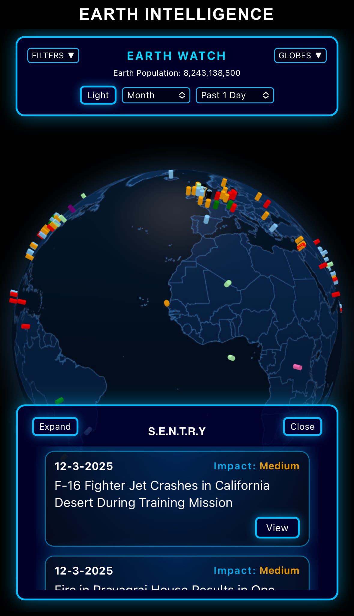
- Click below if you’d like to view our free EARTH WATCH globe:
- Download our mobile app:


Click below to view our previous newsletters:
Support/Suggestions Email:
earthintelligence@earthintel.news